
Mappa topografica Yotei Zan
Mappa interattiva
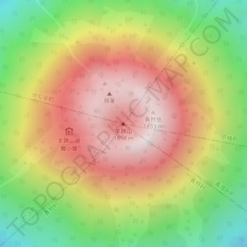
Clicca sulla mappa per visualizzare l'altitudine.
A proposito di questa mappa
Nome: Mappa topografica Yotei Zan, altitudine, rilievo.
Altitudine media: 1.372 m
Altitudine minima: 748 m
Altitudine massima: 1.881 m
In the 50,000:1 scale topographical map of the “Rusutsu” area published in 1920 by Japan’s Land Surveying Department, the mountain is recorded as "Shiribeshi-Yōtei-zan (Ezo-Fuji)". However, since the name was difficult to read, the town of Kutchan asked for it to be changed to Yōtei-zan. The change took place in the November 1969 topographical map published by the Geospatial Information Authority of Japan. Since then, the current name of Yōtei-zan has become established.