
Fai una donazione
Preparati per la tua prossima avventura:
In qualità di associato Amazon, questo sito riceve una commissione sugli acquisti idonei senza alcun costo aggiuntivo per te.
Mappa topografica Yalova
Clicca sulla mappa per visualizzare l'altitudine.
Fai una donazione
Preparati per la tua prossima avventura:
In qualità di associato Amazon, questo sito riceve una commissione sugli acquisti idonei senza alcun costo aggiuntivo per te.
A proposito di questa mappa
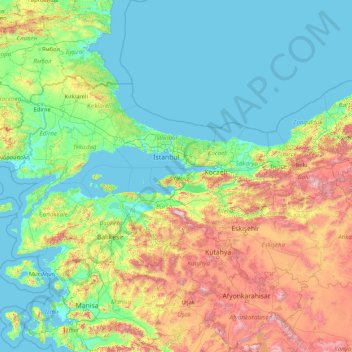
Nome: Mappa topografica Yalova, altitudine, rilievo.
Luogo: Yalova, Marmara Region, Turkey (37.97954 26.56870 43.17954 31.76870)
Altitudine media: 404 m
Altitudine minima: -2 m
Altitudine massima: 2.703 m
Fai una donazione
Preparati per la tua prossima avventura:
In qualità di associato Amazon, questo sito riceve una commissione sugli acquisti idonei senza alcun costo aggiuntivo per te.
Altre mappe topografiche
Clicca su una mappa per visualizzarne la topografia, l'altitudine e il rilievo.
Kaş
As the tenth largest district of Antalya as of 2021, Kaş is on a hill running down to the Turquoise Coast of southwestern Turkey. The district has a typical Mediterranean climate of hot, dry summers and mild, wet winters, which allows the growth of oranges, lemons and bananas. The lowland areas are also…
Altitudine media: 837 m
Fai una donazione
Preparati per la tua prossima avventura:
In qualità di associato Amazon, questo sito riceve una commissione sugli acquisti idonei senza alcun costo aggiuntivo per te.
Antakya
Antakya's climate is classified as hot-summer Mediterranean (Köppen: Csa) or dry-summer humid subtropical (Trewartha: Cf or wet Cs). The city experiences hot, dry summers, and mild, wet winters; though its higher altitude allows for lower temperatures than the coast.
Altitudine media: 385 m
Fai una donazione
Preparati per la tua prossima avventura:
In qualità di associato Amazon, questo sito riceve una commissione sugli acquisti idonei senza alcun costo aggiuntivo per te.
Fai una donazione
Preparati per la tua prossima avventura:
In qualità di associato Amazon, questo sito riceve una commissione sugli acquisti idonei senza alcun costo aggiuntivo per te.
Taurus Mountains
The mountains have a Mediterranean climate, with dry summers and rainy winters. Temperatures vary with elevation, with warm winters on the lower coastal slopes and cold winters in the high mountains and in the interior.
Altitudine media: 828 m
Fai una donazione
Preparati per la tua prossima avventura:
In qualità di associato Amazon, questo sito riceve una commissione sugli acquisti idonei senza alcun costo aggiuntivo per te.
Fai una donazione
Preparati per la tua prossima avventura:
In qualità di associato Amazon, questo sito riceve una commissione sugli acquisti idonei senza alcun costo aggiuntivo per te.
Fai una donazione
Preparati per la tua prossima avventura:
In qualità di associato Amazon, questo sito riceve una commissione sugli acquisti idonei senza alcun costo aggiuntivo per te.
Fai una donazione
Preparati per la tua prossima avventura:
In qualità di associato Amazon, questo sito riceve una commissione sugli acquisti idonei senza alcun costo aggiuntivo per te.
Anatolia
Anatolia (Turkish: Anadolu), also known as Asia Minor, is a peninsula in West Asia that makes up the majority of the land area of Turkey. It is the westernmost protrusion of Asia and is geographically bounded by the Mediterranean Sea to the south, the Aegean Sea to the west, the Turkish Straits to the…
Altitudine media: 518 m
Fai una donazione
Preparati per la tua prossima avventura:
In qualità di associato Amazon, questo sito riceve una commissione sugli acquisti idonei senza alcun costo aggiuntivo per te.
Fai una donazione
Preparati per la tua prossima avventura:
In qualità di associato Amazon, questo sito riceve una commissione sugli acquisti idonei senza alcun costo aggiuntivo per te.
Erdemli
Erdemli is a quiet rural district where the people are conservative, and is traditionally a stronghold of Turkish nationalist politicians; however some departments of Mersin University are opening branches here which will surely have an effect on the cultural and social life of Erdemli in the future. There is…
Altitudine media: 966 m
Zeytinburnu
Zeytinburnu is located on the part of Çatalca peninsula that is apart from historical peninsula with Walls of Constantinople and overlooks to the Marmara Sea in İstanbul. Its altitude generally increases from south to north, and in south districts (Sümer, Nuripaşa, Kazlıçeşme etc.) embankments, alluvium…
Altitudine media: 37 m
Fai una donazione
Preparati per la tua prossima avventura:
In qualità di associato Amazon, questo sito riceve una commissione sugli acquisti idonei senza alcun costo aggiuntivo per te.
Bergama
Kozak Plateau (Kozak Yaylası) is a high plain at an altitude varying between 500 and 1,000 metres (1,600 and 3,300 feet) and starting at a distance of 20 km (12 mi) from Bergama center in the northern direction. The plain is a favorite regional excursion area, famed for its hand-made textile products and pine…
Altitudine media: 323 m
Fai una donazione
Preparati per la tua prossima avventura:
In qualità di associato Amazon, questo sito riceve una commissione sugli acquisti idonei senza alcun costo aggiuntivo per te.
Antalya
The highest point of the Taurus mountains is Akdağ at an altitude of 3025 metres. Located to the northwest of the city centre and at a distance of 50 km (31 mi) is the Saklıkent ski and recreation centre on Beydağları. Here one can ski and then go down to the shore and into the sea during the months of…
Altitudine media: 644 m
Fai una donazione
Preparati per la tua prossima avventura:
In qualità di associato Amazon, questo sito riceve una commissione sugli acquisti idonei senza alcun costo aggiuntivo per te.
Fai una donazione
Preparati per la tua prossima avventura:
In qualità di associato Amazon, questo sito riceve una commissione sugli acquisti idonei senza alcun costo aggiuntivo per te.
Lake Van
Lake Van (Turkish: Van Gölü; Armenian: Վանա լիճ, romanized: Vana lič̣; Kurdish: Gola Wanê) is the largest lake in Turkey. It lies in the Eastern Anatolia Region of Turkey in the provinces of Van and Bitlis, in the Armenian highlands. It is a saline soda lake, receiving water from many small streams…
Altitudine media: 1.902 m
Batman
The province occupies an area of 4,477 km2 (1,729 sq mi). It lies in a mountainous area with the average elevation of 550 meters which contains several thousands of caves. The tallest mountains are Sason Dağları (2500 m), Meleto (2967 m), Kuşaklı Dağı (1947 m), Avcı Dağı (2121 m), Meydanok Tepesi…
Altitudine media: 941 m
Bakırköy
While the average elevation is 20-30 meters throughout Bakırköy, this value rises to 70 meters in the north of the district. The ridges slope north-south towards the Marmara Sea. The coastal length of Bakırköy is 13 km, with small cliffs in Yeşilköy and Yeşilyurt neighborhoods and a sandy beach in Florya.
Altitudine media: 21 m
Fai una donazione
Preparati per la tua prossima avventura:
In qualità di associato Amazon, questo sito riceve una commissione sugli acquisti idonei senza alcun costo aggiuntivo per te.
Fai una donazione
Preparati per la tua prossima avventura:
In qualità di associato Amazon, questo sito riceve una commissione sugli acquisti idonei senza alcun costo aggiuntivo per te.
Anatolia
Anatolia (Turkish: Anadolu), also known as Asia Minor, is a peninsula in West Asia that makes up the majority of the land area of Turkey. It is the westernmost protrusion of Asia and is geographically bounded by the Mediterranean Sea to the south, the Aegean Sea to the west, the Turkish Straits to the…
Altitudine media: 518 m
Fai una donazione
Preparati per la tua prossima avventura:
In qualità di associato Amazon, questo sito riceve una commissione sugli acquisti idonei senza alcun costo aggiuntivo per te.
Fai una donazione
Preparati per la tua prossima avventura:
In qualità di associato Amazon, questo sito riceve una commissione sugli acquisti idonei senza alcun costo aggiuntivo per te.
Batman
The province occupies an area of 4,477 km2 (1,729 sq mi). It lies in a mountainous area with the average elevation of 550 meters which contains several thousands of caves. The tallest mountains are Sason Dağları (2500 m), Meleto (2967 m), Kuşaklı Dağı (1947 m), Avcı Dağı (2121 m), Meydanok Tepesi…
Altitudine media: 941 m
Fai una donazione
Preparati per la tua prossima avventura:
In qualità di associato Amazon, questo sito riceve una commissione sugli acquisti idonei senza alcun costo aggiuntivo per te.
Oludeniz
Ölüdeniz offer a variety of diving opportunities with regard to its crystal clear waters and rich underwater caves and fauna. Scuba diving is the most popular underwater activity. Local diving agencies provide courses and required scuba diving licences. Snorkelling is another diving activity and many sites…
Altitudine media: 541 m
Fai una donazione
Preparati per la tua prossima avventura:
In qualità di associato Amazon, questo sito riceve una commissione sugli acquisti idonei senza alcun costo aggiuntivo per te.
Fai una donazione
Preparati per la tua prossima avventura:
In qualità di associato Amazon, questo sito riceve una commissione sugli acquisti idonei senza alcun costo aggiuntivo per te.
Doğubayazıt
Doğubayazıt (Kurdish: Bazîd; Armenian: Պայազատ, romanized: Payazat or Դարոյնք, Daruynk) is a town of Ağrı Province of Turkey, near the border with Iran. Its elevation is 1625 m. It is the seat of Doğubayazıt District. Its population is 80,061 (2021). Also known as Kurdava, the town was the…
Altitudine media: 1.915 m
Fai una donazione
Preparati per la tua prossima avventura:
In qualità di associato Amazon, questo sito riceve una commissione sugli acquisti idonei senza alcun costo aggiuntivo per te.
Amasra
In the late 8th century its bishop obtained from the Byzantine Emperor its elevation to the rank of autocephalous archeparchy. It is listed as such in the Notitia Episcopatuum attributed to Basil the Armenian (c. 840) and in that of Leo VI the Wise (early 10th century).
Altitudine media: 121 m
Fai una donazione
Preparati per la tua prossima avventura:
In qualità di associato Amazon, questo sito riceve una commissione sugli acquisti idonei senza alcun costo aggiuntivo per te.
Çaykara
Çaykara (Romeika: Kadahor, Κατωχώρι) is a municipality and district of Trabzon Province, Turkey. Its area is 574 km2, and its population is 13,070 (2022). As of 2023, the Mayor of Çaykara is Hanefi Tok (AKP). Çaykara village lies in a V-shaped valley along the Solaklı River in the Pontic Mountains,…
Altitudine media: 1.788 m
Fai una donazione
Preparati per la tua prossima avventura:
In qualità di associato Amazon, questo sito riceve una commissione sugli acquisti idonei senza alcun costo aggiuntivo per te.
Fai una donazione
Preparati per la tua prossima avventura:
In qualità di associato Amazon, questo sito riceve una commissione sugli acquisti idonei senza alcun costo aggiuntivo per te.
Çankaya Belediyesi Ahlatlıbel Atatürk Parkı Sosyal Tesisleri
Turkey > Ankara > Ankara > Çankaya
Altitudine media: 1.199 m
Fai una donazione
Preparati per la tua prossima avventura:
In qualità di associato Amazon, questo sito riceve una commissione sugli acquisti idonei senza alcun costo aggiuntivo per te.