
Fai una donazione
Preparati per la tua prossima avventura:
In qualità di associato Amazon, questo sito riceve una commissione sugli acquisti idonei senza alcun costo aggiuntivo per te.
Mappa topografica Glen Tanar
Clicca sulla mappa per visualizzare l'altitudine.
Fai una donazione
Preparati per la tua prossima avventura:
In qualità di associato Amazon, questo sito riceve una commissione sugli acquisti idonei senza alcun costo aggiuntivo per te.
Glen Tanar
Glen Tanar, along with the side glens formed by the Water of Gairney and the Water of Allachy, comprises the third largest area of Caledonian Forest in Scotland, which grows from the valley floor up to an altitude of 450 metres. As a Caledonian Forest, the predominant tree species is Scots pine, although broad-leaved tree species including birch, alder, rowan, holly, aspen and oak are also present. Juniper grows at the boundary between the forest and the open moorland above, and areas of blaeberry, heather and feather mosses can also be found. the woodland floor provides a habitat for many of the species typically found in the Caledonian Forest, including twinflower, creeping lady's-tresses, toothed wintergreen and intermediate wintergreen.
Fai una donazione
Preparati per la tua prossima avventura:
In qualità di associato Amazon, questo sito riceve una commissione sugli acquisti idonei senza alcun costo aggiuntivo per te.
A proposito di questa mappa
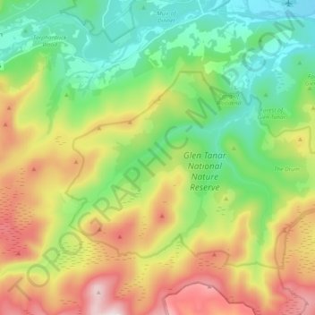
Nome: Mappa topografica Glen Tanar, altitudine, rilievo.
Altitudine media: 389 m
Altitudine minima: 132 m
Altitudine massima: 821 m
Fai una donazione
Preparati per la tua prossima avventura:
In qualità di associato Amazon, questo sito riceve una commissione sugli acquisti idonei senza alcun costo aggiuntivo per te.