
Fai una donazione
Preparati per la tua prossima avventura:
In qualità di associato Amazon, questo sito riceve una commissione sugli acquisti idonei senza alcun costo aggiuntivo per te.
Mappa topografica Webb City
Clicca sulla mappa per visualizzare l'altitudine.
Fai una donazione
Preparati per la tua prossima avventura:
In qualità di associato Amazon, questo sito riceve una commissione sugli acquisti idonei senza alcun costo aggiuntivo per te.
A proposito di questa mappa
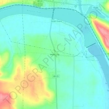
Nome: Mappa topografica Webb City, altitudine, rilievo.
Luogo: Webb City, Franklin County, Arkansas, 72949, United States (35.44814 -93.85186 35.48814 -93.81186)
Altitudine media: 135 m
Altitudine minima: 106 m
Altitudine massima: 213 m
Fai una donazione
Preparati per la tua prossima avventura:
In qualità di associato Amazon, questo sito riceve una commissione sugli acquisti idonei senza alcun costo aggiuntivo per te.
Altre mappe topografiche
Clicca su una mappa per visualizzarne la topografia, l'altitudine e il rilievo.
Wiederkehr Village
United States > Arkansas > Franklin County
Altus had its start in 1875 when the railroad was extended to that point. Altus station was the highest point on the track. In recognition of this highest railroad elevation between Little Rock and Fort Smith, the station was originally known as "Summit". The town's initial development was due to railroad…
Altitudine media: 209 m
Fai una donazione
Preparati per la tua prossima avventura:
In qualità di associato Amazon, questo sito riceve una commissione sugli acquisti idonei senza alcun costo aggiuntivo per te.
Altus
United States > Arkansas > Franklin County
Altus had its start in 1875 when the railroad was extended to that point. Altus station was the highest point on the track. In recognition of this highest railroad elevation between Little Rock and Fort Smith, the station was originally known as "Summit". The town's initial development was due to railroad…
Altitudine media: 192 m