
Mappa topografica Wild Horse Island
Mappa interattiva
Clicca sulla mappa per visualizzare l'altitudine.
A proposito di questa mappa
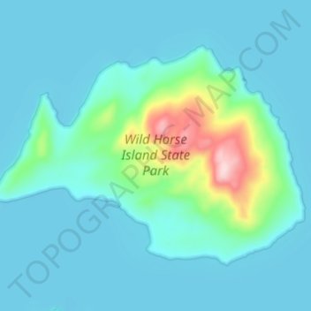
Nome: Mappa topografica Wild Horse Island, altitudine, rilievo.
Luogo: Wild Horse Island, Lake County, Montana, United States (47.82879 -114.24866 47.85777 -114.18785)
Altitudine media: 916 m
Altitudine minima: 879 m
Altitudine massima: 1.139 m
The island was formed by the Cordilleran Glacier, giving the island a varying topography. Its shores are 2,900 feet (880 m) above sea level. The glacier caused the six summits in the center of the island, ranging in heights between 3,277 and 3,745 feet (999 and 1,141 m), to be formed into rôche moutonnée, with rugged northern faces and rugged southern cliffs. Meadows sprawl the western and southern shores, while grasslands cover the southeast. The northern side of the island has forests of Ponderosa pine and Douglas fir trees. The highest point is at 3,749 feet (1,143 m), which is 853 feet (260 m) above the island's shores.
Altre mappe topografiche
Clicca su una mappa per visualizzarne la topografia, l'altitudine e il rilievo.
Flathead Lake
United States > Montana > Lake County
Flathead Lake, Lake County, Montana, United States
Altitudine media: 1.168 m
Picture Lake
United States > Montana > Lake County
Picture Lake, Lake County, Montana, United States
Altitudine media: 2.220 m
Kicking Horse
United States > Montana > Lake County
Kicking Horse, Lake County, Montana, United States
Altitudine media: 938 m