
Fai una donazione
Preparati per la tua prossima avventura:
In qualità di associato Amazon, questo sito riceve una commissione sugli acquisti idonei senza alcun costo aggiuntivo per te.
Mappa topografica North Paravur
Clicca sulla mappa per visualizzare l'altitudine.
Fai una donazione
Preparati per la tua prossima avventura:
In qualità di associato Amazon, questo sito riceve una commissione sugli acquisti idonei senza alcun costo aggiuntivo per te.
North Paravur
Paravur is located at 10.14° N 76.7° E[1]. It has an average elevation of 10 metres (32 feet). The town is situated at north end of Ernakulam district and bordering with Thrissur district. The towns in Thrissur district like Kodungallore, Mala, Chalakudy and the towns Kalamassery, Aluva, Angamaly, Vypin island are located near to this town. The Paravur Taluk lies in the flat delta region of the Periyar river and cut by several canals, which have resulted in the formation of many islands. The Kodungalloor Kayal (backwaters) and Varappuzha Kayal (backwaters) are in this taluk. The town and neighboring areas were deeply affected by floods in 2018 due to heavy rain.
Fai una donazione
Preparati per la tua prossima avventura:
In qualità di associato Amazon, questo sito riceve una commissione sugli acquisti idonei senza alcun costo aggiuntivo per te.
A proposito di questa mappa
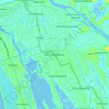
Nome: Mappa topografica North Paravur, altitudine, rilievo.
Luogo: North Paravur, Paravur, Ernakulam, Kerala, 683513, India (10.10841 76.18492 10.18841 76.26492)
Altitudine media: 5 m
Altitudine minima: -3 m
Altitudine massima: 23 m
Fai una donazione
Preparati per la tua prossima avventura:
In qualità di associato Amazon, questo sito riceve una commissione sugli acquisti idonei senza alcun costo aggiuntivo per te.
Altre mappe topografiche
Clicca su una mappa per visualizzarne la topografia, l'altitudine e il rilievo.
Fai una donazione
Preparati per la tua prossima avventura:
In qualità di associato Amazon, questo sito riceve una commissione sugli acquisti idonei senza alcun costo aggiuntivo per te.
periyar river
India > Kerala > Paravur > Manjaly
The southernmost part of the Cardamom Hills i.e. the source of Periyar River is a narrow valley extending south of Kumily. This is the southern extreme of the Periyar basin. It is less than 20 kilometres (12 mi) wide and is about 40 kilometres (25 mi) long. The upper catchments of Periyar extend as a wedge…
Altitudine media: 10 m
Periyar River
India > Kerala > Paravur > Edayar
The southernmost part of the Cardamom Hills i.e. the source of Periyar River is a narrow valley extending south of Kumily. This is the southern extreme of the Periyar basin. It is less than 20 kilometres (12 mi) wide and is about 40 kilometres (25 mi) long. The upper catchments of Periyar extend as a wedge…
Altitudine media: 8 m
Fai una donazione
Preparati per la tua prossima avventura:
In qualità di associato Amazon, questo sito riceve una commissione sugli acquisti idonei senza alcun costo aggiuntivo per te.