
Fai una donazione
Preparati per la tua prossima avventura:
In qualità di associato Amazon, questo sito riceve una commissione sugli acquisti idonei senza alcun costo aggiuntivo per te.
Mappa topografica Morristown
Clicca sulla mappa per visualizzare l'altitudine.
Fai una donazione
Preparati per la tua prossima avventura:
In qualità di associato Amazon, questo sito riceve una commissione sugli acquisti idonei senza alcun costo aggiuntivo per te.
Morristown
Morristown falls in the humid subtropical climate zone (Köppen climate classification Cfa), although it is not quite as hot as areas to the south and west of Tennessee due to the higher elevations. Summers are hot and humid, with July highs averaging 85 °F (29 °C), lows averaging 66 °F (19 °C), and an average of eight days per year with temperatures above 90 °F (32 °C). Winters are generally cool, with occasional small amounts of snow. January averages a high of around 45 °F (7 °C) and a low of around 28 °F (−2 °C), although low temperatures in the single digits and teens are not uncommon. The record high for Morristown, since 1994, is 103 °F (39 °C), while the record low is −2 °F (−19 °C). Annual precipitation averages around 44.3 in (1,125 mm), and average winter snowfall is 11.7 inches (30 cm). The average monthly relative humidity is around 70 percent.
Fai una donazione
Preparati per la tua prossima avventura:
In qualità di associato Amazon, questo sito riceve una commissione sugli acquisti idonei senza alcun costo aggiuntivo per te.
A proposito di questa mappa
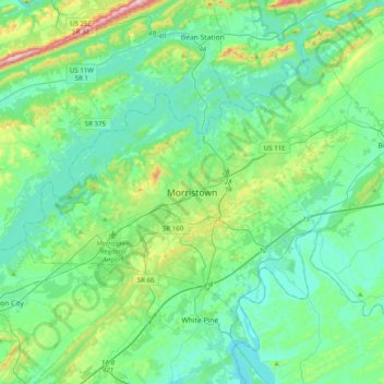
Nome: Mappa topografica Morristown, altitudine, rilievo.
Luogo: Morristown, Hamblen County, Tennessee, 37814, United States (36.05398 -83.45489 36.37398 -83.13489)
Altitudine media: 378 m
Altitudine minima: 289 m
Altitudine massima: 745 m
Fai una donazione
Preparati per la tua prossima avventura:
In qualità di associato Amazon, questo sito riceve una commissione sugli acquisti idonei senza alcun costo aggiuntivo per te.