
Mappa topografica Bothell
Clicca sulla mappa per visualizzare l'altitudine.
Bothell
Other events are hosted by community organizations, such as the annual Bothell block party and brewfest sponsored by University of Washington Bothell and the local chamber of commerce. The annual "Sustainamania" has been held in Bothell since 2012 to promote sustainable living, conservation, and education. A weekly community market, named the Bothell Friday Market, launched in 2019 in response to the closure of Country Village, which formerly hosted a farmers' market. An annual bicycle ride, named the Summits of Bothell, was held in the 2000s along a 38-mile (61 km) course in the city with 3,250 feet (990 m) of elevation gain. In 2007, about 5,000 to 7,000 people gathered for a parade and outdoor concert at the Veterans Memorial Amphitheater at Bothell Landing in honor of local American Idol contestant Blake Lewis. The Cup of Kindness Day, created by a local coffeeshop owner and held on May 10, 2018, was cited by Reader's Digest in its awarding of "Nicest Places in America" honors to Bothell and nine other cities that year.
A proposito di questa mappa
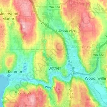
Nome: Mappa topografica Bothell, altitudine, rilievo.
Luogo: Bothell, King County, Washington, United States (47.73237 -122.24927 47.81455 -122.16353)
Altitudine media: 68 m
Altitudine minima: -1 m
Altitudine massima: 162 m
Altre mappe topografiche
Clicca su una mappa per visualizzarne la topografia, l'altitudine e il rilievo.
Mount Si
United States > Washington > King County
The peak can be accessed by two trails. The Old Mount Si trail is accessed by the Little Si parking lot and the Boulder Garden Loop. It is 0.6 miles (0.97 km) shorter, 270 feet (82 m) steeper in elevation gain, and less crowded than the main trail. The Mount Si trail is accessed by the Mount Si parking lot.
Altitudine media: 793 m
West Hylebos Wetlands Park
United States > Washington > King County > Federal Way
Altitudine media: 84 m
Stevens Pass
United States > Washington > King County
Stevens Pass (elevation 4,061 ft (1,238 m)) is a mountain pass through the Cascade Mountains located at the border of King County and Chelan County in Washington, United States. U.S. Route 2 travels over the pass, reaching a maximum elevation of 4,061 feet (1,238 m). The Pacific Crest Trail crosses the highway…
Altitudine media: 1.387 m
Preston
United States > Washington > King County
Preston is a historic mill town on the northeast edge of the large Tiger Mountain State Forest, along Interstate 90. Preston, elevation 430 ft (130 m), is located within commuting distance of Seattle and Bellevue.
Altitudine media: 270 m
Hot Springs
United States > Washington > King County
Hot Springs is located east of Enumclaw and just west of Lester, along the Green River and BNSF Railway line. Its elevation is 1512 feet (460m) above sea level.
Altitudine media: 588 m
Stampede Pass
United States > Washington > King County
Stampede Pass (elevation 3,672 feet (1,119 m)) is a mountain pass in the northwest United States, through the Cascade Range in Washington. Southeast of Seattle and east of Tacoma, its importance to transportation lies almost entirely with railroading, as no paved roads cross it. It is approximately twelve…
Altitudine media: 1.135 m
Mercer Island
United States > Washington > King County > Mercer Island
Mercer Island City Hall is located at 47°34′39″N 122°12′43.2″W / 47.57750°N 122.212000°W / 47.57750; -122.212000 (47.5775, -122.212). The peak elevation in the city is about 338 feet (103 m), near the center of the island.
Altitudine media: 39 m
Mount Index
United States > Washington > King County
Mount Index is a peak in the central part of the Cascade Range of Washington state. It lies just south of the Skykomish River and U.S. Route 2, at the western edge of the Cascades. Despite its low elevation relative to peaks higher in the Cascades, it is a famous and dramatic landmark due to its topographic…
Altitudine media: 1.178 m
Mount Si
United States > Washington > King County
The peak can be accessed by two trails. The Old Mount Si trail is accessed by the Little Si parking lot and the Boulder Garden Loop. It is 0.6 miles (0.97 km) shorter, 270 feet (82 m) steeper in elevation gain, and less crowded than the main trail. The Mount Si trail is accessed by the Mount Si parking lot.
Altitudine media: 787 m
Lester
United States > Washington > King County
Lester is located, east of Enumclaw, Washington along the Green River and BNSF Railway line. Its elevation is 1,634 feet (498 m) above sea level.
Altitudine media: 690 m
Hot Springs
United States > Washington > King County
Hot Springs is located east of Enumclaw and just west of Lester, along the Green River and BNSF Railway line. Its elevation is 1512 feet (460m) above sea level.
Altitudine media: 588 m
Mount Si
United States > Washington > King County
The peak can be accessed by two trails. The Old Mount Si trail is accessed by the Little Si parking lot and the Boulder Garden Loop. It is 0.6 miles (0.97 km) shorter, 270 feet (82 m) steeper in elevation gain, and less crowded than the main trail. The Mount Si trail is accessed by the Mount Si parking lot.
Altitudine media: 787 m
Maple Valley
United States > Washington > King County > Maple Valley > Maple Valley
Altitudine media: 166 m
Lake Forest Park
United States > Washington > King County > Lake Forest Park > Lake Forest Park
Altitudine media: 85 m