
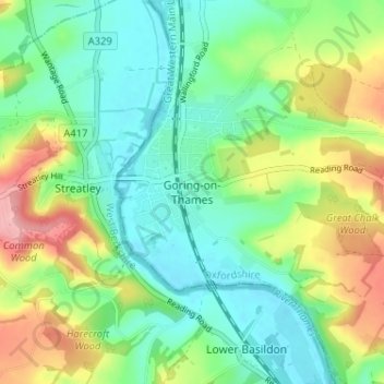
Mappa topografica Goring-on-Thames
Mappa interattiva
Clicca sulla mappa per visualizzare l'altitudine.
A proposito di questa mappa
Nome: Mappa topografica Goring-on-Thames, altitudine, rilievo.
Altitudine media: 84 m
Altitudine minima: 38 m
Altitudine massima: 175 m
Altre mappe topografiche
Clicca su una mappa per visualizzarne la topografia, l'altitudine e il rilievo.
Sonning Common
United Kingdom > England > Oxfordshire > South Oxfordshire > Sonning Common
Sonning Common, South Oxfordshire, Oxfordshire, England, United Kingdom
Altitudine media: 88 m
Goring-on-Thames
United Kingdom > England > Oxfordshire > South Oxfordshire
Goring-on-Thames, South Oxfordshire, Oxfordshire, England, United Kingdom
Altitudine media: 87 m
Britwell Salome
United Kingdom > England > Oxfordshire > South Oxfordshire
Britwell Salome, South Oxfordshire, Oxfordshire, England, United Kingdom
Altitudine media: 123 m
Sonning Eye
United Kingdom > England > Oxfordshire > South Oxfordshire > Dunsden Green
Sonning Eye, Eye and Dunsden, Dunsden Green, South Oxfordshire, Oxfordshire, England, RG4 6TN, United Kingdom
Altitudine media: 51 m
Dorchester On Thames
United Kingdom > England > Oxfordshire > South Oxfordshire
Dorchester On Thames, South Oxfordshire, Oxfordshire, England, OX10 7HH, United Kingdom
Altitudine media: 54 m
North Moreton
United Kingdom > England > Oxfordshire > South Oxfordshire
North Moreton, South Oxfordshire, Oxfordshire, England, United Kingdom
Altitudine media: 60 m
Cholsey
United Kingdom > England > Oxfordshire > South Oxfordshire
Cholsey, South Oxfordshire, Oxfordshire, England, United Kingdom
Altitudine media: 67 m
Thame
United Kingdom > England > Oxfordshire > South Oxfordshire
Thame, South Oxfordshire, Oxfordshire, England, United Kingdom
Altitudine media: 74 m
Didcot
United Kingdom > England > Oxfordshire > South Oxfordshire
Didcot, South Oxfordshire, Oxfordshire, England, United Kingdom
Altitudine media: 61 m
Woodcote
United Kingdom > England > Oxfordshire > South Oxfordshire
Woodcote, South Oxfordshire, Oxfordshire, England, United Kingdom
Altitudine media: 136 m
Wallingford
United Kingdom > England > Oxfordshire > South Oxfordshire > Crowmarsh Gifford
Wallingford, Crowmarsh Gifford, South Oxfordshire, Oxfordshire, England, United Kingdom
Altitudine media: 51 m
South Oxfordshire
United Kingdom > England > Oxfordshire > South Oxfordshire
South Oxfordshire, Oxfordshire, England, United Kingdom
Altitudine media: 97 m
Milton Common
United Kingdom > England > Oxfordshire > South Oxfordshire
Milton Common, Great Milton, South Oxfordshire, Oxfordshire, England, OX9 2NS, United Kingdom
Altitudine media: 81 m
Henley-on-Thames
United Kingdom > England > Oxfordshire > South Oxfordshire
Henley-on-Thames, South Oxfordshire, Oxfordshire, England, RG9 2AN, United Kingdom
Altitudine media: 78 m