
Fai una donazione
Preparati per la tua prossima avventura:
In qualità di associato Amazon, questo sito riceve una commissione sugli acquisti idonei senza alcun costo aggiuntivo per te.
Mappa topografica Limestone
Clicca sulla mappa per visualizzare l'altitudine.
Fai una donazione
Preparati per la tua prossima avventura:
In qualità di associato Amazon, questo sito riceve una commissione sugli acquisti idonei senza alcun costo aggiuntivo per te.
A proposito di questa mappa
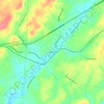
Nome: Mappa topografica Limestone, altitudine, rilievo.
Altitudine media: 447 m
Altitudine minima: 413 m
Altitudine massima: 501 m
Fai una donazione
Preparati per la tua prossima avventura:
In qualità di associato Amazon, questo sito riceve una commissione sugli acquisti idonei senza alcun costo aggiuntivo per te.
Altre mappe topografiche
Clicca su una mappa per visualizzarne la topografia, l'altitudine e il rilievo.
Johnson City
United States > Tennessee > Washington County
Johnson City occupies a broad Appalachian valley in northeastern Tennessee, where the smoother urban floor around Sinking Creek and Brush Creek sits at roughly 1,600 feet (488 meters) above sea level and is framed by progressively higher, more rugged terrain. The landscape reflects the Ridge-and-Valley…
Altitudine media: 513 m
Fai una donazione
Preparati per la tua prossima avventura:
In qualità di associato Amazon, questo sito riceve una commissione sugli acquisti idonei senza alcun costo aggiuntivo per te.
Johnson City
United States > Tennessee > Washington County
Johnson City occupies a broad Appalachian valley in northeastern Tennessee, where the smoother urban floor around Sinking Creek and Brush Creek sits at roughly 1,600 feet (488 meters) above sea level and is framed by progressively higher, more rugged terrain. The landscape reflects the Ridge-and-Valley…
Altitudine media: 513 m