
Fai una donazione
Preparati per la tua prossima avventura:
In qualità di associato Amazon, questo sito riceve una commissione sugli acquisti idonei senza alcun costo aggiuntivo per te.
Mappa topografica Chiribiquete (Macizo Central)
Clicca sulla mappa per visualizzare l'altitudine.
Fai una donazione
Preparati per la tua prossima avventura:
In qualità di associato Amazon, questo sito riceve una commissione sugli acquisti idonei senza alcun costo aggiuntivo per te.
Chiribiquete (Macizo Central)
Chiribiquete National Park is situated in the western region of the Guiana Shield, east of the Eastern Cordillera, north of the Amazonian plains, west of the Upper Río Negro, and south of the savannas of the Orinoquía. Elevations in the park range from about 200 to 1,000 metres above sea level. It contains geological formations that are made up of plateaus and steep rocky structures. The formations are divided into three different sections: the Northern Massif, the Central Massif and Iguaje Messas. The park is well known for its tepuis, table-top mountains that abruptly rise from the forest. The mountain ridge of Chiribiquete is an important remnant of the rocky chain belonging to the Precambrian and Paleozoic formations that make up the Guiana Shield.
Fai una donazione
Preparati per la tua prossima avventura:
In qualità di associato Amazon, questo sito riceve una commissione sugli acquisti idonei senza alcun costo aggiuntivo per te.
A proposito di questa mappa
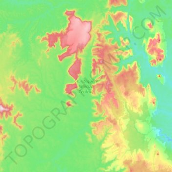
Nome: Mappa topografica Chiribiquete (Macizo Central), altitudine, rilievo.
Luogo: Chiribiquete (Macizo Central), Solano, Caquetá, Colombia (0.38732 -72.96391 0.79344 -72.67372)
Altitudine media: 290 m
Altitudine minima: 154 m
Altitudine massima: 588 m
Fai una donazione
Preparati per la tua prossima avventura:
In qualità di associato Amazon, questo sito riceve una commissione sugli acquisti idonei senza alcun costo aggiuntivo per te.
Altre mappe topografiche
Clicca su una mappa per visualizzarne la topografia, l'altitudine e il rilievo.