
Mappa topografica Chinon
Mappa interattiva
Clicca sulla mappa per visualizzare l'altitudine.
A proposito di questa mappa
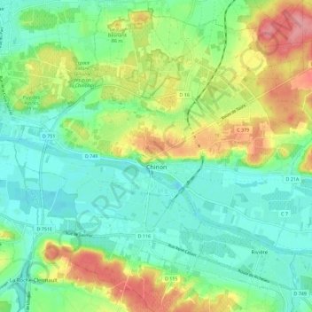
Nome: Mappa topografica Chinon, altitudine, rilievo.
Altitudine media: 58 m
Altitudine minima: 24 m
Altitudine massima: 124 m
Topography has played a major role: the formerly fortified town was developed at the foot of the castle on the rocky outcrop, protecting the northern side, with the Vienne River in the south. Apart from the natural defensive protection on both sides, this fact makes a long narrow urban space, with the main streets running parallel to the river.
Altre mappe topografiche
Clicca su una mappa per visualizzarne la topografia, l'altitudine e il rilievo.
La Vrillonerie
France > Centre-Val de Loire > Indre-et-Loire > Chambray-lès-Tours
La Vrillonerie, Chambray-lès-Tours, Tours, Indre-et-Loire, Centre-Val de Loire, Metropolitan France, 37170, France
Altitudine media: 89 m
Crotelles
France > Centre-Val de Loire > Indre-et-Loire
Crotelles, Loches, Indre-et-Loire, Centre-Val de Loire, Metropolitan France, 37380, France
Altitudine media: 130 m
Tours
France > Centre-Val de Loire > Indre-et-Loire
Tours, Arrondissement de Tours, Indre-et-Loire, Centre-Val de Loire, Metropolitan France, France
Altitudine media: 73 m
Rigny-Ussé
France > Centre-Val de Loire > Indre-et-Loire
Rigny-Ussé, Arrondissement de Tours, Indre-et-Loire, Centre-Val de Loire, Metropolitan France, 37420, France
Altitudine media: 74 m