
Mappa topografica Edenderry
Mappa interattiva
Clicca sulla mappa per visualizzare l'altitudine.
A proposito di questa mappa
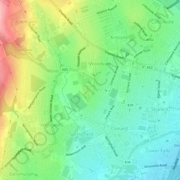
Nome: Mappa topografica Edenderry, altitudine, rilievo.
Altitudine media: 50 m
Altitudine minima: 2 m
Altitudine massima: 138 m
Altre mappe topografiche
Clicca su una mappa per visualizzarne la topografia, l'altitudine e il rilievo.
Ballygomartin
United Kingdom > Northern Ireland > County Antrim > Belfast
Ballygomartin, Ligoniel, Belfast, County Antrim, Northern Ireland, United Kingdom
Altitudine media: 258 m
Botanic Gardens
United Kingdom > Northern Ireland > County Antrim > Belfast
Botanic Gardens, Queen's Quarter, Belfast, County Antrim, Northern Ireland, United Kingdom
Altitudine media: 15 m
Cavehill
United Kingdom > Northern Ireland > County Antrim > Belfast
Cavehill, Belfast, County Antrim, Northern Ireland, BT36 7PN, United Kingdom
Altitudine media: 188 m
McArt's Fort
United Kingdom > Northern Ireland > County Antrim > Belfast
McArt's Fort, Ben Madigan Heights, Whitewell, Belfast, County Antrim, Northern Ireland, BT36 7RW, United Kingdom
Altitudine media: 165 m