
Mappa topografica Ua Pou
Mappa interattiva
Clicca sulla mappa per visualizzare l'altitudine.
A proposito di questa mappa
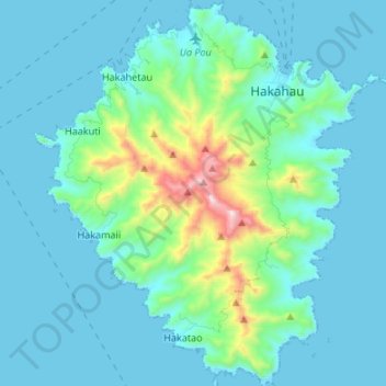
Nome: Mappa topografica Ua Pou, altitudine, rilievo.
Luogo: Ua Pou, Marquesas Islands, French Polynesia, France (-9.46723 -140.13578 -9.33490 -140.01976)
Altitudine media: 127 m
Altitudine minima: -4 m
Altitudine massima: 919 m
The center of the island is characterized by four high basalt pillars that reach high above the surrounding mountains. The highest of these pillars, Mount Oave (Mont Oave), reaches to 1,230 m (4,040 ft) above sea level and is the highest elevation in the Marquesas.