
Fai una donazione
Preparati per la tua prossima avventura:
In qualità di associato Amazon, questo sito riceve una commissione sugli acquisti idonei senza alcun costo aggiuntivo per te.
Mappa topografica Love Canal
Clicca sulla mappa per visualizzare l'altitudine.
Fai una donazione
Preparati per la tua prossima avventura:
In qualità di associato Amazon, questo sito riceve una commissione sugli acquisti idonei senza alcun costo aggiuntivo per te.
Love Canal
Residents were suspicious of black fluid that flowed out of the Love Canal. For years, residents had complained about odors and substances in their yards or the public playgrounds. Finally, the city acted and hired a consultant, Calspan Corporation, to do a far-reaching study. In 1977, a harsh winter storm dumped 33–45 inches (84–114 cm) of snow, significantly raising the water table. The excess water got into the ground water and raised the elevation of contaminants including dioxin. During the spring of 1977, the State Departments of Health and Environmental Conservation began an intensive air, soil, and groundwater sampling and analysis program after qualitative identification of a number of organic compounds in the basements of 11 homes adjacent to the Love Canal. It was also revealed that the standards at the time did not require the installation of a liner to prevent leaching; this became very common among companies.
Fai una donazione
Preparati per la tua prossima avventura:
In qualità di associato Amazon, questo sito riceve una commissione sugli acquisti idonei senza alcun costo aggiuntivo per te.
A proposito di questa mappa
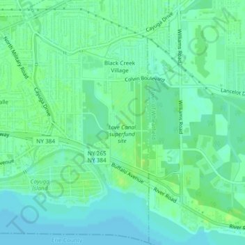
Nome: Mappa topografica Love Canal, altitudine, rilievo.
Altitudine media: 176 m
Altitudine minima: 170 m
Altitudine massima: 181 m
Fai una donazione
Preparati per la tua prossima avventura:
In qualità di associato Amazon, questo sito riceve una commissione sugli acquisti idonei senza alcun costo aggiuntivo per te.