Geolocalizza

Mappa topografica Grand Rapids

Mappa interattiva

Clicca sulla mappa per visualizzare l'altitudine.

A proposito di questa mappa

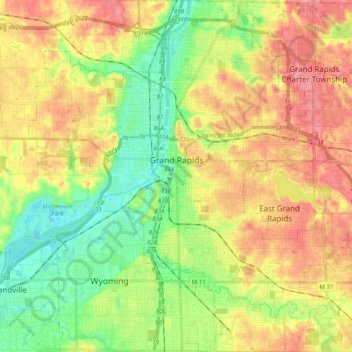
Nome: Mappa topografica Grand Rapids, altitudine, rilievo.

Luogo: Grand Rapids, Kent County, Michigan, United States (42.88365 -85.75153 43.02905 -85.56865)

Altitudine media: 216 m

Altitudine minima: 178 m

Altitudine massima: 257 m

Grand Rapids developed on the banks of the Grand River, where there was once a set of rapids, at an altitude of 610 feet (186 m) above sea level. Ships could navigate on the river up to this fall line, stopping because of the rapids. The river valley is flat and narrow, surrounded by steep hills and bluffs. The terrain becomes more rolling hills away from the river. The countryside surrounding the metropolitan area consists of mixed forest and farmland, with large areas of orchards to the northwest. It is approximately 25 mi (40 km) east of Lake Michigan. The state capital of Lansing lies about 60 mi (97 km) to the east-by-southeast, and Kalamazoo is about 50 mi (80 km) to the south.

Wikipedia (CC-BY-SA 3.0)

Altre mappe topografiche

Clicca su una mappa per visualizzarne la topografia, l'altitudine e il rilievo.

Cannonsburg

United States > Michigan > Kent County > Cannon Township

Cannonsburg, Cannon Township, Kent County, Michigan, 49317, United States

Altitudine media: 256 m

Scram Lake

United States > Michigan > Kent County

Scram Lake, Oakfield Township, Kent County, Michigan, United States

Altitudine media: 270 m

Walker

United States > Michigan > Kent County

Walker, Kent County, Michigan, United States

Altitudine media: 209 m

Forest Hills

United States > Michigan > Kent County > Ada Township

Forest Hills, Ada Township, Kent County, Michigan, United States

Altitudine media: 229 m

Comstock Park

United States > Michigan > Kent County > Plainfield Charter Township

Comstock Park, Plainfield Charter Township, Kent County, Michigan, United States

Altitudine media: 206 m

Rockford

United States > Michigan > Kent County

Rockford, Kent County, Michigan, 49351, United States

Altitudine media: 239 m

Northview

United States > Michigan > Kent County > Plainfield Charter Township

Northview, Plainfield Charter Township, Kent County, Michigan, United States

Altitudine media: 216 m

Wyoming

United States > Michigan > Kent County

Wyoming, Kent County, Michigan, United States

Altitudine media: 204 m

Cordes Lake

United States > Michigan > Kent County

Cordes Lake, Courtland Township, Kent County, Michigan, United States

Altitudine media: 275 m

Kentwood

United States > Michigan > Kent County

Kentwood, Kent County, Michigan, United States

Altitudine media: 216 m

Solon Township

United States > Michigan > Kent County

Solon Township, Kent County, Michigan, United States

Altitudine media: 263 m

East Grand Rapids

United States > Michigan > Kent County

East Grand Rapids, Kent County, Michigan, 49506, United States

Altitudine media: 232 m

Gaines Township

United States > Michigan > Kent County

Gaines Township, Kent County, Michigan, 49316, United States

Altitudine media: 243 m

Vergennes Township

United States > Michigan > Kent County

Vergennes Township, Kent County, Michigan, United States

Altitudine media: 242 m

Alton

United States > Michigan > Kent County > Vergennes Township

Alton, Vergennes Township, Kent County, Michigan, United States

Altitudine media: 254 m

Byron Center

United States > Michigan > Kent County > Byron Center

Byron Center, Byron Township, Kent County, Michigan, United States

Altitudine media: 225 m

Tyrone Township

United States > Michigan > Kent County

Tyrone Township, Kent County, Michigan, 49330, United States

Altitudine media: 249 m

Ada Township

United States > Michigan > Kent County

Ada Township, Kent County, Michigan, United States

Altitudine media: 228 m

Cascade Charter Township

United States > Michigan > Kent County

Cascade Charter Township, Kent County, Michigan, 49546, United States

Altitudine media: 229 m

Ratigan Lake

United States > Michigan > Kent County > Cannon Township

Ratigan Lake, Cannon Township, Grattan Township, Kent County, Michigan, United States

Altitudine media: 260 m

Ada

United States > Michigan > Kent County > Ada Township

Ada, Ada Township, Kent County, Michigan, 49355, United States

Altitudine media: 208 m

Alto

United States > Michigan > Kent County

Alto, Bowne Township, Kent County, Michigan, United States

Altitudine media: 252 m

Lake Leota

United States > Michigan > Kent County > Walker

Lake Leota, Walker, Kent County, Michigan, United States

Altitudine media: 199 m

Sparta Township

United States > Michigan > Kent County

Sparta Township, Kent County, Michigan, 49345, United States

Altitudine media: 246 m

Alaska

United States > Michigan > Kent County

Alaska, Caledonia Township, Kent County, Michigan, United States

Altitudine media: 230 m

Grandville

United States > Michigan > Kent County

Grandville, Kent County, Michigan, 49418, United States

Altitudine media: 193 m

Kentwood

United States > Michigan > Kent County > Kentwood

Kentwood, Kent County, Michigan, 49548, United States

Altitudine media: 218 m

Caledonia

United States > Michigan > Kent County > Caledonia Charter Township

Caledonia, Caledonia Charter Township, Kent County, Michigan, United States

Altitudine media: 243 m

Lowell

United States > Michigan > Kent County

Lowell, Kent County, Michigan, United States

Altitudine media: 206 m

Cedar Springs

United States > Michigan > Kent County

Cedar Springs, Kent County, Michigan, 49319, United States

Altitudine media: 262 m

Byron Township

United States > Michigan > Kent County

Byron Township, Kent County, Michigan, 49315, United States

Altitudine media: 221 m

Sand Lake

United States > Michigan > Kent County

Sand Lake, Nelson Township, Kent County, Michigan, United States

Altitudine media: 277 m