
Mappa topografica Bridport
Clicca sulla mappa per visualizzare l'altitudine.
Bridport
Bridport is in the county of Dorset in South West England. Measured directly, it is about 14 miles (23 km) west of the county town Dorchester, 15.5 miles (25 km) SSW of Yeovil in Somerset, 33 miles (53 km) east of Exeter in Devon and 1.5 miles (2.4 km) inland from the English Channel at West Bay. The town centre is sited between the small River Brit and its tributary the Asker, about 0.5 miles (0.8 km) north of their confluence, at an altitude of 10–15 metres (33–49 ft). Another small tributary, the River Simene, also joins the Brit to the west of the town centre.
A proposito di questa mappa
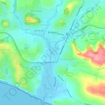
Nome: Mappa topografica Bridport, altitudine, rilievo.
Luogo: Bridport, Dorset, England, United Kingdom (50.70847 -2.77586 50.75705 -2.72027)
Altitudine media: 39 m
Altitudine minima: -3 m
Altitudine massima: 142 m
Altre mappe topografiche
Clicca su una mappa per visualizzarne la topografia, l'altitudine e il rilievo.
River Frome
United Kingdom > England > Dorset > Maiden Newton > Frome Vauchurch
Altitudine media: 132 m
Middlemarsh
United Kingdom > England > Dorset > Glanvilles Wootton > Middlemarsh
Altitudine media: 116 m