
Mappa topografica Khan Shaykhun
Mappa interattiva
Clicca sulla mappa per visualizzare l'altitudine.
A proposito di questa mappa
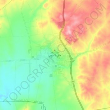
Nome: Mappa topografica Khan Shaykhun, altitudine, rilievo.
Altitudine media: 385 m
Altitudine minima: 311 m
Altitudine massima: 480 m
Khan Shaykhun is located at an altitude of 350 meters on the main highway between Aleppo and Damascus. The local economy is primarily agricultural, focusing on the growing of cotton and cereals. The town was formerly known for producing embroidery. Nearby localities include Hbit to the west, Kafr Zita to southwest, Murak to the south and Al-Tamanah to the east. In 2004, it was recorded as having 34,371 inhabitants.
Altre mappe topografiche
Clicca su una mappa per visualizzarne la topografia, l'altitudine e il rilievo.
Idlib District
Idlib District, Idlib Governorate, Syria
Altitudine media: 392 m
Jisr ash-Shugur
Syria > Idlib Governorate > Jisr ash-Shugur
Jisr ash-Shugur, Jish Al-Shughur Subdistrict, Jish Al-Shughur District, Idlib Governorate, Syria
Altitudine media: 444 m
Salhab
Salhab, Darkush Subdistrict, Jisr Al-Shughur District, Idlib Governorate, Syria
Altitudine media: 421 m