
Fai una donazione
Preparati per la tua prossima avventura:
In qualità di associato Amazon, questo sito riceve una commissione sugli acquisti idonei senza alcun costo aggiuntivo per te.
Mappa topografica Bellefonte
Clicca sulla mappa per visualizzare l'altitudine.
Fai una donazione
Preparati per la tua prossima avventura:
In qualità di associato Amazon, questo sito riceve una commissione sugli acquisti idonei senza alcun costo aggiuntivo per te.
Bellefonte
The city is located on a one-mile wide belt of relatively flat land that is approximately 100 feet higher in elevation than the nearby Ohio River valley. The unusual topography which is easily noticeable on topographical maps and aerial satellite imagery was created by the ancient Teays River. Larger than the Ohio River, the Teays cut a mile wide valley through the area before being filled with glacial silt during the ice age. This belt of flat land extends from Catlettsburg where it leaves the Ohio River north to near Wurtland and includes parts of Ashland, Westwood, Bellefonte, Russell and Flatwoods. The Ohio River came after the ice age in its current path which created another valley just northeast of Bellefonte. This entire belt of flat land was once known as The Flatwoods beginning in the mid-19th century. The name was retained when it was applied to the nearby city of Flatwoods, just northwest of Bellefonte.
Fai una donazione
Preparati per la tua prossima avventura:
In qualità di associato Amazon, questo sito riceve una commissione sugli acquisti idonei senza alcun costo aggiuntivo per te.
A proposito di questa mappa
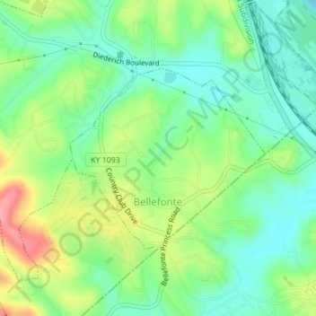
Nome: Mappa topografica Bellefonte, altitudine, rilievo.
Luogo: Bellefonte, Greenup County, Kentucky, United States (38.48856 -82.69979 38.50399 -82.67844)
Altitudine media: 188 m
Altitudine minima: 155 m
Altitudine massima: 246 m
Fai una donazione
Preparati per la tua prossima avventura:
In qualità di associato Amazon, questo sito riceve una commissione sugli acquisti idonei senza alcun costo aggiuntivo per te.
Altre mappe topografiche
Clicca su una mappa per visualizzarne la topografia, l'altitudine e il rilievo.
Fai una donazione
Preparati per la tua prossima avventura:
In qualità di associato Amazon, questo sito riceve una commissione sugli acquisti idonei senza alcun costo aggiuntivo per te.