
Fai una donazione
Preparati per la tua prossima avventura:
In qualità di associato Amazon, questo sito riceve una commissione sugli acquisti idonei senza alcun costo aggiuntivo per te.
Mappa topografica Duanesburg
Clicca sulla mappa per visualizzare l'altitudine.
Fai una donazione
Preparati per la tua prossima avventura:
In qualità di associato Amazon, questo sito riceve una commissione sugli acquisti idonei senza alcun costo aggiuntivo per te.
Duanesburg
The town consists of mostly wooded hills up to an elevation of approximately 1,400 feet (430 m) above sea level. Most of the town was cleared farmland until the late 20th century. After this point forests grew to cover 60% of the total land area with a canopy higher than 40 feet (12 m). The forest is primary composed of poplar, hemlock, oak, maple, white pine, and balsam fir. The maximum tree heights in Duanesburg are approximately 80 feet (24 m) high.
Fai una donazione
Preparati per la tua prossima avventura:
In qualità di associato Amazon, questo sito riceve una commissione sugli acquisti idonei senza alcun costo aggiuntivo per te.
A proposito di questa mappa
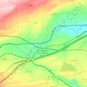
Nome: Mappa topografica Duanesburg, altitudine, rilievo.
Altitudine media: 267 m
Altitudine minima: 154 m
Altitudine massima: 410 m
Fai una donazione
Preparati per la tua prossima avventura:
In qualità di associato Amazon, questo sito riceve una commissione sugli acquisti idonei senza alcun costo aggiuntivo per te.