
Mappa topografica Bellshill
Clicca sulla mappa per visualizzare l'altitudine.
A proposito di questa mappa
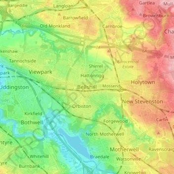
Nome: Mappa topografica Bellshill, altitudine, rilievo.
Altitudine media: 73 m
Altitudine minima: 17 m
Altitudine massima: 150 m
Altre mappe topografiche
Clicca su una mappa per visualizzarne la topografia, l'altitudine e il rilievo.
Forrestburn Reservoir
United Kingdom > Scotland > North Lanarkshire > Bentfoot
Altitudine media: 231 m
Cumbernauld
United Kingdom > Scotland > North Lanarkshire
Cumbernauld's name probably comes from the Gaelic comar nan allt, meaning "meeting of the burns or streams". There are differing views as to the etymology of this. One theory is that from its high point in the Central Belt, its streams flow both west to the River Clyde and east to the Firth of Forth so…
Altitudine media: 113 m