
Mappa topografica Bitumount
Clicca sulla mappa per visualizzare l'altitudine.
A proposito di questa mappa
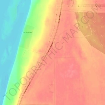
Nome: Mappa topografica Bitumount, altitudine, rilievo.
Luogo: Bitumount, Wood Buffalo, Alberta, Canada (57.37213 -111.64210 57.39213 -111.62210)
Altitudine media: 272 m
Altitudine minima: 227 m
Altitudine massima: 294 m
Altre mappe topografiche
Clicca su una mappa per visualizzarne la topografia, l'altitudine e il rilievo.
Fort McMurray
Canada > Alberta > Wood Buffalo
The community lies at a lower elevation than most other parts of Alberta, so under the right conditions it can be a "hot spot" for Alberta.
Altitudine media: 345 m
Fort McKay
Canada > Alberta > Wood Buffalo
Fort McKay (/məˈkaɪ/ mə-KY) or Fort MacKay is a community in northeast Alberta, Canada that is located at the confluence of the Athabasca and MacKay rivers. It is approximately 54 km (34 mi) north of Fort McMurray via Highway 63 and Fort McKay Road. The community has an elevation of 260 m (850 ft).
Altitudine media: 259 m
Fort McMurray
Canada > Alberta > Wood Buffalo
The community lies at a lower elevation than most other parts of Alberta, so under the right conditions it can be a "hot spot" for Alberta.
Altitudine media: 346 m
Fort McKay
Canada > Alberta > Wood Buffalo
Fort McKay (/məˈkaɪ/ mə-KY) or Fort MacKay is a community in northeast Alberta, Canada, located at the confluence of the Athabasca and MacKay rivers. It is approximately 54 km (34 mi) north of Fort McMurray via Highway 63 and Fort McKay Road. The community has an elevation of 260 m (850 ft).
Altitudine media: 259 m