
Fai una donazione
Preparati per la tua prossima avventura:
In qualità di associato Amazon, questo sito riceve una commissione sugli acquisti idonei senza alcun costo aggiuntivo per te.
Mappa topografica Winnabow
Clicca sulla mappa per visualizzare l'altitudine.
Fai una donazione
Preparati per la tua prossima avventura:
In qualità di associato Amazon, questo sito riceve una commissione sugli acquisti idonei senza alcun costo aggiuntivo per te.
A proposito di questa mappa
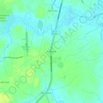
Nome: Mappa topografica Winnabow, altitudine, rilievo.
Luogo: Winnabow, Brunswick County, North Carolina, United States (34.12934 -78.11360 34.16934 -78.07360)
Altitudine media: 7 m
Altitudine minima: -1 m
Altitudine massima: 18 m
Fai una donazione
Preparati per la tua prossima avventura:
In qualità di associato Amazon, questo sito riceve una commissione sugli acquisti idonei senza alcun costo aggiuntivo per te.
Altre mappe topografiche
Clicca su una mappa per visualizzarne la topografia, l'altitudine e il rilievo.
Ocean Isle Beach
United States > North Carolina > Brunswick County
Ocean Isle Beach is a picturesque barrier island characterized by its low-lying terrain and sandy shorelines. The topography features an average elevation of about 3 feet (1 meter) above sea level, with the landscape gently sloping towards the Atlantic Ocean. The island spans approximately 7 miles in length…
Altitudine media: 4 m
Fai una donazione
Preparati per la tua prossima avventura:
In qualità di associato Amazon, questo sito riceve una commissione sugli acquisti idonei senza alcun costo aggiuntivo per te.
Fai una donazione
Preparati per la tua prossima avventura:
In qualità di associato Amazon, questo sito riceve una commissione sugli acquisti idonei senza alcun costo aggiuntivo per te.
Caswell Beach
United States > North Carolina > Brunswick County
Roughly halfway distant from Wilmington, North Carolina and Myrtle Beach, South Carolina, Caswell Beach is located on the east end of Oak Island. This island is the easternmost of the South Brunswick Islands which were formed in the late 1930s by the construction of the Intracoastal Waterway (ICW) which was…
Altitudine media: 1 m
Fai una donazione
Preparati per la tua prossima avventura:
In qualità di associato Amazon, questo sito riceve una commissione sugli acquisti idonei senza alcun costo aggiuntivo per te.
Bald Head Island
United States > North Carolina > Brunswick County
Located at the tip of Cape Fear and residing at the convergence of the Cape Fear River and Atlantic Gulf Stream, the land mass of Bald Head Island ends, trailing off into 30 miles (48 km) of treacherous sand bars known as Frying Pan Shoals. In this area, large sand bars seasonally emerge from and subsequently…
Altitudine media: 0 m
Fai una donazione
Preparati per la tua prossima avventura:
In qualità di associato Amazon, questo sito riceve una commissione sugli acquisti idonei senza alcun costo aggiuntivo per te.
Fai una donazione
Preparati per la tua prossima avventura:
In qualità di associato Amazon, questo sito riceve una commissione sugli acquisti idonei senza alcun costo aggiuntivo per te.