
Fai una donazione
Preparati per la tua prossima avventura:
In qualità di associato Amazon, questo sito riceve una commissione sugli acquisti idonei senza alcun costo aggiuntivo per te.
Mappa topografica Snellville
Clicca sulla mappa per visualizzare l'altitudine.
Fai una donazione
Preparati per la tua prossima avventura:
In qualità di associato Amazon, questo sito riceve una commissione sugli acquisti idonei senza alcun costo aggiuntivo per te.
Snellville
Compared to most large cities around the world at approximately the same latitude (33°39'), such as Beirut, Casablanca, Dallas, Los Angeles, and Phoenix, Snellville has lower average winter temperatures. The primary reason for this is that the North American continent extends into high latitudes that allows systems to form and move eastward and southward without obstruction by major mountain ranges. Other factors include Snellville's distance from large bodies of water; its higher elevation, which can lead to rapid weather changes; prevailing wind patterns; and extensive tree cover, which reduces the urban heat island effect (an advantage during summer).
Fai una donazione
Preparati per la tua prossima avventura:
In qualità di associato Amazon, questo sito riceve una commissione sugli acquisti idonei senza alcun costo aggiuntivo per te.
A proposito di questa mappa
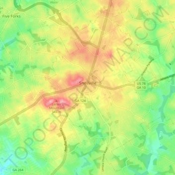
Nome: Mappa topografica Snellville, altitudine, rilievo.
Luogo: Snellville, Gwinnett County, Georgia, United States (33.81839 -84.04291 33.89217 -83.95093)
Altitudine media: 300 m
Altitudine minima: 247 m
Altitudine massima: 363 m
Fai una donazione
Preparati per la tua prossima avventura:
In qualità di associato Amazon, questo sito riceve una commissione sugli acquisti idonei senza alcun costo aggiuntivo per te.
Altre mappe topografiche
Clicca su una mappa per visualizzarne la topografia, l'altitudine e il rilievo.
Yellow River Post Office Site
United States > Georgia > Gwinnett County > Lilburn
Altitudine media: 275 m
Fai una donazione
Preparati per la tua prossima avventura:
In qualità di associato Amazon, questo sito riceve una commissione sugli acquisti idonei senza alcun costo aggiuntivo per te.
Pine Ridge Country Club Estates
United States > Georgia > Gwinnett County > Lawrenceville
Altitudine media: 323 m
Fai una donazione
Preparati per la tua prossima avventura:
In qualità di associato Amazon, questo sito riceve una commissione sugli acquisti idonei senza alcun costo aggiuntivo per te.