
Fai una donazione
Preparati per la tua prossima avventura:
In qualità di associato Amazon, questo sito riceve una commissione sugli acquisti idonei senza alcun costo aggiuntivo per te.
Mappa topografica Cedar Hill
Clicca sulla mappa per visualizzare l'altitudine.
Fai una donazione
Preparati per la tua prossima avventura:
In qualità di associato Amazon, questo sito riceve una commissione sugli acquisti idonei senza alcun costo aggiuntivo per te.
Cedar Hill
It is sometimes referred to as the "hill country of Dallas" (in comparison to the "hill country" surrounding Austin and San Antonio). The city is full of native eastern red cedar evergreen trees and stands at an elevation of about 800 feet (240 m) above sea level—the highest point in a straight line from the Red River at the Texas-Oklahoma border to the Gulf Coast.
Fai una donazione
Preparati per la tua prossima avventura:
In qualità di associato Amazon, questo sito riceve una commissione sugli acquisti idonei senza alcun costo aggiuntivo per te.
A proposito di questa mappa
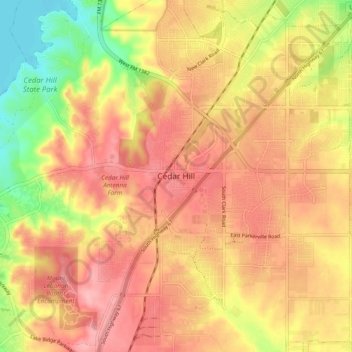
Nome: Mappa topografica Cedar Hill, altitudine, rilievo.
Luogo: Cedar Hill, Dallas County, Texas, 75104-2135, United States (32.54881 -96.99537 32.62881 -96.91537)
Altitudine media: 225 m
Altitudine minima: 156 m
Altitudine massima: 268 m
Fai una donazione
Preparati per la tua prossima avventura:
In qualità di associato Amazon, questo sito riceve una commissione sugli acquisti idonei senza alcun costo aggiuntivo per te.