
Fai una donazione
Preparati per la tua prossima avventura:
In qualità di associato Amazon, questo sito riceve una commissione sugli acquisti idonei senza alcun costo aggiuntivo per te.
Mappa topografica White Lake Charter Township
Clicca sulla mappa per visualizzare l'altitudine.
Fai una donazione
Preparati per la tua prossima avventura:
In qualità di associato Amazon, questo sito riceve una commissione sugli acquisti idonei senza alcun costo aggiuntivo per te.
A proposito di questa mappa
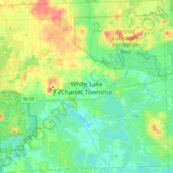
Nome: Mappa topografica White Lake Charter Township, altitudine, rilievo.
Altitudine media: 303 m
Altitudine minima: 277 m
Altitudine massima: 355 m
Fai una donazione
Preparati per la tua prossima avventura:
In qualità di associato Amazon, questo sito riceve una commissione sugli acquisti idonei senza alcun costo aggiuntivo per te.
Altre mappe topografiche
Clicca su una mappa per visualizzarne la topografia, l'altitudine e il rilievo.
Fai una donazione
Preparati per la tua prossima avventura:
In qualità di associato Amazon, questo sito riceve una commissione sugli acquisti idonei senza alcun costo aggiuntivo per te.
Jossman Acres
United States > Michigan > Oakland County > Springfield Charter Township
Altitudine media: 324 m
Fai una donazione
Preparati per la tua prossima avventura:
In qualità di associato Amazon, questo sito riceve una commissione sugli acquisti idonei senza alcun costo aggiuntivo per te.
Union Lake
United States > Michigan > Oakland County > White Lake Charter Township
Altitudine media: 290 m
Carpenter Lake Nature Preserve
United States > Michigan > Oakland County > Southfield
Altitudine media: 207 m
Fai una donazione
Preparati per la tua prossima avventura:
In qualità di associato Amazon, questo sito riceve una commissione sugli acquisti idonei senza alcun costo aggiuntivo per te.
Dollar Lake
United States > Michigan > Oakland County > Independence Charter Township
Altitudine media: 306 m
Cranberry Lake
United States > Michigan > Oakland County > White Lake Charter Township
Altitudine media: 295 m
Fai una donazione
Preparati per la tua prossima avventura:
In qualità di associato Amazon, questo sito riceve una commissione sugli acquisti idonei senza alcun costo aggiuntivo per te.
Huron Heights
United States > Michigan > Oakland County > Waterford Charter Township
Altitudine media: 292 m
Davisburg
United States > Michigan > Oakland County > Springfield Charter Township
Altitudine media: 309 m
Fai una donazione
Preparati per la tua prossima avventura:
In qualità di associato Amazon, questo sito riceve una commissione sugli acquisti idonei senza alcun costo aggiuntivo per te.
Rochester Hills
United States > Michigan > Oakland County > Rochester Hills
Rochester Hills is bordered to the north by Oakland Charter Township along Dutton Road, to the south by the city of Troy along South Boulevard, to the east by Shelby Township in Macomb County along Dequindre Road, and to the west by the city of Auburn Hills along part of Adams Road. Rochester Hills is also…
Altitudine media: 246 m