
Mappa topografica Necanicum River
Mappa interattiva
Clicca sulla mappa per visualizzare l'altitudine.
A proposito di questa mappa
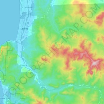
Nome: Mappa topografica Necanicum River, altitudine, rilievo.
Altitudine media: 185 m
Altitudine minima: -2 m
Altitudine massima: 707 m
The Necanicum River rises south of Humbug Mountain (not to be confused with the Humbug Mountain in southwestern Oregon), in south central Clatsop County and south of the Saddle Mountain State Natural Area. The elevation of the river's source is approximately 1,847 feet (563 m). It flows generally west, along U.S. Route 26. Approximately 3 miles (4.8 km) from the coast, east of Tillamook Head, it turns north. The river enters the Pacific Ocean at Seaside. Its final approach to the ocean is nearly parallel to the coast running south to north through the downtown of Seaside.
Altre mappe topografiche
Clicca su una mappa per visualizzarne la topografia, l'altitudine e il rilievo.
Cascade Range
United States of America > Oregon
Cascade Range, Marion County, Oregon, United States of America
Altitudine media: 690 m
Springfield
United States of America > Oregon > Springfield > Springfield
Springfield, Lane County, Oregon, 97477-2635, United States of America
Altitudine media: 226 m
Washington Park
United States of America > Oregon > Portland
Washington Park, 4033, Arlington Heights, Portland, Multnomah County, Oregon, 97221, United States of America
Altitudine media: 169 m
Imnaha River Woods Development
United States of America > Oregon > Imnaha River Woods Development
Imnaha River Woods Development, Wallowa County, Oregon, United States of America
Altitudine media: 1.331 m
Crescent Lake
United States of America > Oregon > Crescent Lake
Odell Lake, Crescent Lake, Klamath County, Oregon, United States of America
Altitudine media: 1.492 m
Pine Point
United States of America > Oregon
Pine Point, Curry County, Oregon, United States of America
Altitudine media: 353 m
The Villages at Mount Hood
United States of America > Oregon
The Villages at Mount Hood, Clackamas County, Oregon, United States of America
Altitudine media: 797 m
Charleston
United States of America > Oregon > Charleston
Charleston, Coos County, Oregon, United States of America
Altitudine media: 24 m
The Peaks
United States of America > Oregon
The Peaks, Harney County, Oregon, United States of America
Altitudine media: 1.825 m
Riddle
United States of America > Oregon > Riddle
Riddle, Douglas County, Oregon, United States of America
Altitudine media: 246 m
Scholls
United States of America > Oregon > Scholls
Scholls, Washington County, Oregon, United States of America
Altitudine media: 52 m
Buxton
United States of America > Oregon > Buxton
Buxton, Washington County, Oregon, 97125, United States of America
Altitudine media: 146 m
Iron Knob
United States of America > Oregon
Iron Knob, Jackson County, Oregon, United States of America
Altitudine media: 861 m
Cape Blanco
United States of America > Oregon
Cape Blanco, Cape Blanco Road, Curry County, Oregon, United States of America
Altitudine media: 9 m
Tierra Del Mar
United States of America > Oregon > Tierra Del Mar
Tierra Del Mar, Tillamook County, Oregon, 97135, United States of America
Altitudine media: 67 m
Horse Ridge
United States of America > Oregon
Horse Ridge, Deschutes County, Oregon, United States of America
Altitudine media: 1.390 m
Table Rock
United States of America > Oregon > Brookings
Table Rock, Brookings, Curry County, Oregon, 97415, United States of America
Altitudine media: 242 m
Lebanon Dam
United States of America > Oregon
Lebanon Dam, Linn County, Oregon, United States of America
Altitudine media: 149 m
Boring
United States of America > Oregon > Boring
Boring, Clackamas County, Oregon, 97009, United States of America
Altitudine media: 183 m
Upper Highland
United States of America > Oregon > Upper Highland
Upper Highland, Clackamas County, Oregon, United States of America
Altitudine media: 365 m
Tick Hill
United States of America > Oregon
Tick Hill, Wallowa County, Oregon, 97885, United States of America
Altitudine media: 990 m
Tillamook
United States of America > Oregon > Tillamook > Tillamook
Tillamook, Tillamook County, Oregon, United States of America
Altitudine media: 4 m