
Fai una donazione
Preparati per la tua prossima avventura:
In qualità di associato Amazon, questo sito riceve una commissione sugli acquisti idonei senza alcun costo aggiuntivo per te.
Mappa topografica Mount Guiting-Guiting
Clicca sulla mappa per visualizzare l'altitudine.
Fai una donazione
Preparati per la tua prossima avventura:
In qualità di associato Amazon, questo sito riceve una commissione sugli acquisti idonei senza alcun costo aggiuntivo per te.
Mount Guiting-Guiting
Mount Guiting-Guiting or G2 is the highest mountain in the province of Romblon, located in Sibuyan Island, in the Philippines, with an elevation of 6,752 ft (2,058 m) above sea level. Its steep slopes and jagged peak, have earned it the reputation, as one of the most difficult and technically most challenging mountain to climb in the Philippines. Ranked 11th-most prominent mountain in Philippines, and 71st-highest peak of an island in the world. Located at the heart of Sibuyan and dominates the landscape for miles around. Guiting-Guiting, in the Romblomanon dialect means "jagged". It is one of the focal points of Sibuyan's declaration as a biodiversity haven and has been dubbed by some local and international natural scientists as The Galapagos of Asia. The island of Sibuyan has been compared numerous times with the biodiversity endemism rate of the Galapagos islands in Ecuador.
Fai una donazione
Preparati per la tua prossima avventura:
In qualità di associato Amazon, questo sito riceve una commissione sugli acquisti idonei senza alcun costo aggiuntivo per te.
A proposito di questa mappa
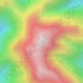
Nome: Mappa topografica Mount Guiting-Guiting, altitudine, rilievo.
Altitudine media: 1.478 m
Altitudine minima: 773 m
Altitudine massima: 2.010 m
Fai una donazione
Preparati per la tua prossima avventura:
In qualità di associato Amazon, questo sito riceve una commissione sugli acquisti idonei senza alcun costo aggiuntivo per te.