
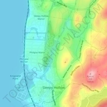
Mappa topografica Village of Sleepy Hollow
Mappa interattiva
Clicca sulla mappa per visualizzare l'altitudine.
A proposito di questa mappa
Nome: Mappa topografica Village of Sleepy Hollow, altitudine, rilievo.
Altitudine media: 46 m
Altitudine minima: 0 m
Altitudine massima: 147 m
Altre mappe topografiche
Clicca su una mappa per visualizzarne la topografia, l'altitudine e il rilievo.
Thornwood
United States > New York > Westchester County > Town of Mount Pleasant
Thornwood, Town of Mount Pleasant, Westchester County, New York, 10594, United States
Altitudine media: 121 m
Hawthorne
United States > New York > Westchester County > Town of Mount Pleasant
Hawthorne, Town of Mount Pleasant, Westchester County, New York, 10532, United States
Altitudine media: 114 m
Valhalla
United States > New York > Westchester County > Town of Mount Pleasant
Valhalla, Town of Mount Pleasant, Westchester County, New York, 10595, United States
Altitudine media: 109 m
Village of Pleasantville
United States > New York > Westchester County > Town of Mount Pleasant
Village of Pleasantville, Town of Mount Pleasant, Westchester County, New York, 10570, United States
Altitudine media: 124 m