
Fai una donazione
Preparati per la tua prossima avventura:
In qualità di associato Amazon, questo sito riceve una commissione sugli acquisti idonei senza alcun costo aggiuntivo per te.
Mappa topografica Folsom
Clicca sulla mappa per visualizzare l'altitudine.
Fai una donazione
Preparati per la tua prossima avventura:
In qualità di associato Amazon, questo sito riceve una commissione sugli acquisti idonei senza alcun costo aggiuntivo per te.
Folsom
Folsom is situated in a wide valley near the headwaters of the Cimarron River, locally known as the Dry Cimarron, as it runs underground during part of its course through eastern New Mexico. The village is ringed by buttes, mesas, and old volcanic cones and lava flows. Most of the valley is rich grassland, with a pinyon pine and juniper forest found on slopes and in rocky areas. Ponderosa pines are found in canyons and at higher elevations. Large ranches and cattle grazing are typical of the area, although some irrigated agriculture is found downstream from Folsom. Hunting for deer, bear, elk, pronghorn, and turkey is popular on local ranches.
Fai una donazione
Preparati per la tua prossima avventura:
In qualità di associato Amazon, questo sito riceve una commissione sugli acquisti idonei senza alcun costo aggiuntivo per te.
A proposito di questa mappa
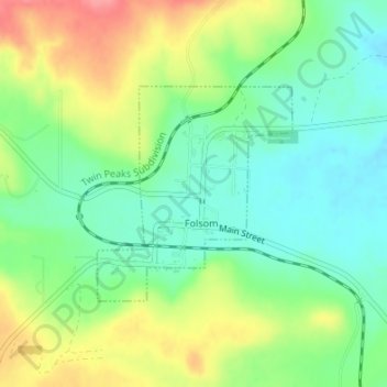
Nome: Mappa topografica Folsom, altitudine, rilievo.
Luogo: Folsom, Union County, New Mexico, United States (36.83959 -103.92685 36.85459 -103.90980)
Altitudine media: 1.970 m
Altitudine minima: 1.938 m
Altitudine massima: 2.020 m
Fai una donazione
Preparati per la tua prossima avventura:
In qualità di associato Amazon, questo sito riceve una commissione sugli acquisti idonei senza alcun costo aggiuntivo per te.