
Mappa topografica Yorktown Heights
Mappa interattiva
Clicca sulla mappa per visualizzare l'altitudine.
A proposito di questa mappa
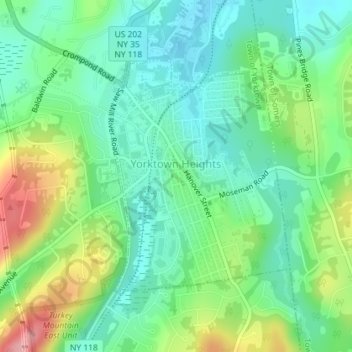
Nome: Mappa topografica Yorktown Heights, altitudine, rilievo.
Altitudine media: 159 m
Altitudine minima: 117 m
Altitudine massima: 246 m
Altre mappe topografiche
Clicca su una mappa per visualizzarne la topografia, l'altitudine e il rilievo.
Lake Mohansic
United States > New York > Westchester County > Town of Yorktown
Lake Mohansic, Town of Yorktown, Westchester County, New York, United States
Altitudine media: 159 m
Lake Mohegan
United States > New York > Westchester County > Town of Yorktown
Lake Mohegan, Town of Yorktown, Westchester County, New York, 10547, United States
Altitudine media: 140 m
Shrub Oak
United States > New York > Westchester County > Town of Yorktown
Shrub Oak, Town of Yorktown, Westchester County, New York, 10588, United States
Altitudine media: 156 m
Turkey Mountain
United States > New York > Westchester County > Town of Yorktown
Turkey Mountain, Town of Yorktown, Westchester County, New York, United States
Altitudine media: 142 m