
Mappa topografica Huntley
Mappa interattiva
Clicca sulla mappa per visualizzare l'altitudine.
A proposito di questa mappa
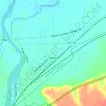
Nome: Mappa topografica Huntley, altitudine, rilievo.
Luogo: Huntley, Yellowstone County, Montana, United States (45.88711 -108.31916 45.91403 -108.29097)
Altitudine media: 924 m
Altitudine minima: 911 m
Altitudine massima: 965 m
During the Yellowstone Flood of 1937, the damage to Huntley was more extensive, percentage-wise, than in any other community in the region. Much of the original town of Huntley was destroyed and significant portions of the land it occupied was claimed or compromised by the Yellowstone River. The flood damage included washing away the suspension bridge that allowed adjacent Highway 312 to cross the river. After the flood, the site of the town was relocated from the north side of the river to the higher elevation on the south bank.
Altre mappe topografiche
Clicca su una mappa per visualizzarne la topografia, l'altitudine e il rilievo.
Billings
United States > Montana > Yellowstone County
Billings, Yellowstone County, Montana, United States
Altitudine media: 1.023 m
Laurel
United States > Montana > Yellowstone County
Laurel, Yellowstone County, Montana, United States
Altitudine media: 1.019 m
Yegen
United States > Montana > Yellowstone County
Yegen, Yellowstone County, Montana, United States
Altitudine media: 981 m