
Mappa topografica North Allis Township
Mappa interattiva
Clicca sulla mappa per visualizzare l'altitudine.
A proposito di questa mappa
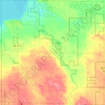
Nome: Mappa topografica North Allis Township, altitudine, rilievo.
Altitudine media: 224 m
Altitudine minima: 182 m
Altitudine massima: 269 m
Altre mappe topografiche
Clicca su una mappa per visualizzarne la topografia, l'altitudine e il rilievo.
Sinkhole
United States > Michigan > Presque Isle County > Presque Isle Township
Sinkhole, Presque Isle Township, Presque Isle County, Michigan, United States
Altitudine media: 192 m
Ocqueoc
United States > Michigan > Presque Isle County
Ocqueoc, Ocqueoc Township, Presque Isle County, Michigan, United States
Altitudine media: 226 m
Case Township
United States > Michigan > Presque Isle County
Case Township, Presque Isle County, Michigan, United States
Altitudine media: 253 m
Hessler Lake
United States > Michigan > Presque Isle County
Hessler Lake, Case Township, Presque Isle County, Michigan, United States
Altitudine media: 260 m
Presque Isle Township
United States > Michigan > Presque Isle County
Presque Isle Township, Presque Isle County, Michigan, 49777, United States
Altitudine media: 187 m
Posen
United States > Michigan > Presque Isle County
Posen, Posen Township, Presque Isle County, Michigan, United States
Altitudine media: 238 m
Grand Island
United States > Michigan > Presque Isle County > Presque Isle Township
Grand Island, Presque Isle Township, Presque Isle County, Michigan, United States
Altitudine media: 182 m
Manitou Beach
United States > Michigan > Presque Isle County > Manitou Beach
Manitou Beach, Rogers Township, Presque Isle County, Michigan, United States
Altitudine media: 184 m
Rogers City
United States > Michigan > Presque Isle County
Rogers City, Presque Isle County, Michigan, 49779, United States
Altitudine media: 188 m