
Fai una donazione
Preparati per la tua prossima avventura:
In qualità di associato Amazon, questo sito riceve una commissione sugli acquisti idonei senza alcun costo aggiuntivo per te.
Mappa topografica Modasa
Clicca sulla mappa per visualizzare l'altitudine.
Fai una donazione
Preparati per la tua prossima avventura:
In qualità di associato Amazon, questo sito riceve una commissione sugli acquisti idonei senza alcun costo aggiuntivo per te.
Modasa
Modasa is located at 23°28′N 73°18′E / 23.47°N 73.3°E / 23.47; 73.3. It has an average elevation of 197 metres (646 feet). Most of the water for Modasa comes from the Mazum river, on which, about 5 kilometers from Modasa, the Mazum reservoir is situated.
Fai una donazione
Preparati per la tua prossima avventura:
In qualità di associato Amazon, questo sito riceve una commissione sugli acquisti idonei senza alcun costo aggiuntivo per te.
A proposito di questa mappa
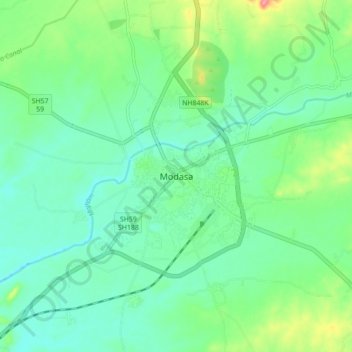
Nome: Mappa topografica Modasa, altitudine, rilievo.
Luogo: Modasa, Modasa Taluka, Aravalli, Gujarat, 383315, India (23.42342 73.25906 23.50342 73.33906)
Altitudine media: 149 m
Altitudine minima: 125 m
Altitudine massima: 211 m
Fai una donazione
Preparati per la tua prossima avventura:
In qualità di associato Amazon, questo sito riceve una commissione sugli acquisti idonei senza alcun costo aggiuntivo per te.