
Fai una donazione
Preparati per la tua prossima avventura:
In qualità di associato Amazon, questo sito riceve una commissione sugli acquisti idonei senza alcun costo aggiuntivo per te.
Mappa topografica Roxboro
Clicca sulla mappa per visualizzare l'altitudine.
Fai una donazione
Preparati per la tua prossima avventura:
In qualità di associato Amazon, questo sito riceve una commissione sugli acquisti idonei senza alcun costo aggiuntivo per te.
Roxboro
Roxboro receives an average of 7.2 in (183 mm) of snow per winter. Freezing rain and sleet occur most winters, and occasionally the area experiences a major, damaging ice storm. Roxboro is often dubbed the "Snow Capital of the Triangle" because it often receives the most or close to the most snow during snowstorms in central North Carolina due to its high elevation.
Fai una donazione
Preparati per la tua prossima avventura:
In qualità di associato Amazon, questo sito riceve una commissione sugli acquisti idonei senza alcun costo aggiuntivo per te.
A proposito di questa mappa
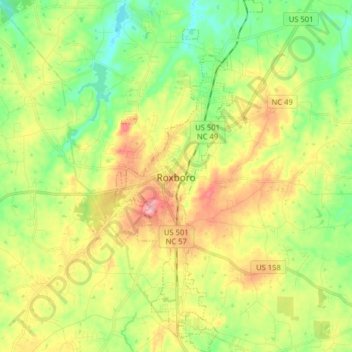
Nome: Mappa topografica Roxboro, altitudine, rilievo.
Luogo: Roxboro, Person County, North Carolina, 27573, United States (36.33009 -79.01072 36.45819 -78.94375)
Altitudine media: 191 m
Altitudine minima: 134 m
Altitudine massima: 270 m
Fai una donazione
Preparati per la tua prossima avventura:
In qualità di associato Amazon, questo sito riceve una commissione sugli acquisti idonei senza alcun costo aggiuntivo per te.
Altre mappe topografiche
Clicca su una mappa per visualizzarne la topografia, l'altitudine e il rilievo.
Fai una donazione
Preparati per la tua prossima avventura:
In qualità di associato Amazon, questo sito riceve una commissione sugli acquisti idonei senza alcun costo aggiuntivo per te.