
Fai una donazione
Preparati per la tua prossima avventura:
In qualità di associato Amazon, questo sito riceve una commissione sugli acquisti idonei senza alcun costo aggiuntivo per te.
Mappa topografica Detroit River
Clicca sulla mappa per visualizzare l'altitudine.
Fai una donazione
Preparati per la tua prossima avventura:
In qualità di associato Amazon, questo sito riceve una commissione sugli acquisti idonei senza alcun costo aggiuntivo per te.
Detroit River
The Detroit River is only 0.5–2.5 miles (0.8–4.0 km) wide. It begins with an east-to-west flow from Lake St. Clair, but curves and runs north to south. The deepest portion of the Detroit River is 53 feet (16.2 m) in its northern portion. At its source, the river is at an elevation of 574 feet (175 m) above sea level. The river is relatively level, dropping only 3 feet (0.9 m) before entering Lake Erie at 571 feet (174 m). As the river contains no dams and no locks, it is easily navigable by even the smallest of vessels. The watershed basin for the Detroit River is approximately 700 square miles (1,800 km2).
Fai una donazione
Preparati per la tua prossima avventura:
In qualità di associato Amazon, questo sito riceve una commissione sugli acquisti idonei senza alcun costo aggiuntivo per te.
A proposito di questa mappa
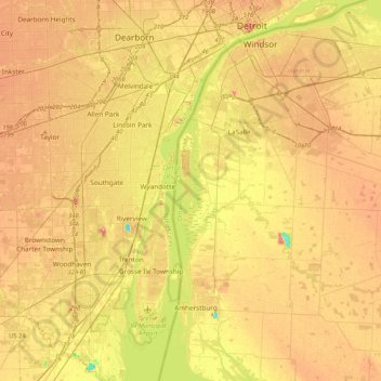
Nome: Mappa topografica Detroit River, altitudine, rilievo.
Altitudine media: 183 m
Altitudine minima: 136 m
Altitudine massima: 218 m
Fai una donazione
Preparati per la tua prossima avventura:
In qualità di associato Amazon, questo sito riceve una commissione sugli acquisti idonei senza alcun costo aggiuntivo per te.
Altre mappe topografiche
Clicca su una mappa per visualizzarne la topografia, l'altitudine e il rilievo.