
Fai una donazione
Preparati per la tua prossima avventura:
In qualità di associato Amazon, questo sito riceve una commissione sugli acquisti idonei senza alcun costo aggiuntivo per te.
Mappa topografica Hills
Clicca sulla mappa per visualizzare l'altitudine.
Fai una donazione
Preparati per la tua prossima avventura:
In qualità di associato Amazon, questo sito riceve una commissione sugli acquisti idonei senza alcun costo aggiuntivo per te.
Hills
According to the United States Census Bureau, the city has a total area of 0.54 square miles (1.40 km2); 0.53 square miles (1.37 km2) is land and 0.01 square miles (0.03 km2) is water. The landscape is flat with some gently rolling hills; however, the town's name does not derive from a particular topographical feature. The town includes two parks, Jacobson Park and the Rez. The Rez is a man made reservoir that is used for swimming, fishing and outdoor recreation. A gravel path circles the Rez (reservoir) and there are two small playgrounds. Multiple campsites and a cabin are also on the property as well as a disc golf course.
Fai una donazione
Preparati per la tua prossima avventura:
In qualità di associato Amazon, questo sito riceve una commissione sugli acquisti idonei senza alcun costo aggiuntivo per te.
A proposito di questa mappa
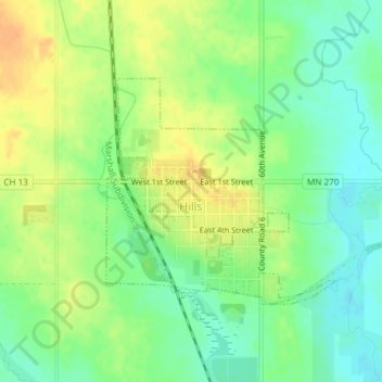
Nome: Mappa topografica Hills, altitudine, rilievo.
Altitudine media: 445 m
Altitudine minima: 429 m
Altitudine massima: 463 m
Fai una donazione
Preparati per la tua prossima avventura:
In qualità di associato Amazon, questo sito riceve una commissione sugli acquisti idonei senza alcun costo aggiuntivo per te.