
Fai una donazione
Preparati per la tua prossima avventura:
In qualità di associato Amazon, questo sito riceve una commissione sugli acquisti idonei senza alcun costo aggiuntivo per te.
Mappa topografica Coulter
Clicca sulla mappa per visualizzare l'altitudine.
Fai una donazione
Preparati per la tua prossima avventura:
In qualità di associato Amazon, questo sito riceve una commissione sugli acquisti idonei senza alcun costo aggiuntivo per te.
A proposito di questa mappa
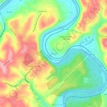
Nome: Mappa topografica Coulter, altitudine, rilievo.
Altitudine media: 287 m
Altitudine minima: 219 m
Altitudine massima: 373 m
Fai una donazione
Preparati per la tua prossima avventura:
In qualità di associato Amazon, questo sito riceve una commissione sugli acquisti idonei senza alcun costo aggiuntivo per te.
Altre mappe topografiche
Clicca su una mappa per visualizzarne la topografia, l'altitudine e il rilievo.
South Park
United States > Pennsylvania > Allegheny County > South Park Township
Altitudine media: 335 m
Brackenridge
United States > Pennsylvania > Allegheny County
Brackenridge is located at 40°36′30″N 79°44′32″W / 40.60833°N 79.74222°W / 40.60833; -79.74222. The borough's average elevation is 827 feet (252 m) above sea level. According to the U.S. Census Bureau, the borough has a total area of 0.6 square miles (1.6 km2), of which 0.5 square miles…
Altitudine media: 266 m
Fai una donazione
Preparati per la tua prossima avventura:
In qualità di associato Amazon, questo sito riceve una commissione sugli acquisti idonei senza alcun costo aggiuntivo per te.
Fai una donazione
Preparati per la tua prossima avventura:
In qualità di associato Amazon, questo sito riceve una commissione sugli acquisti idonei senza alcun costo aggiuntivo per te.
Russellton
United States > Pennsylvania > Allegheny County > West Deer Township
Altitudine media: 325 m
Curtisville
United States > Pennsylvania > Allegheny County > West Deer Township > Curtisville
Altitudine media: 344 m
Fai una donazione
Preparati per la tua prossima avventura:
In qualità di associato Amazon, questo sito riceve una commissione sugli acquisti idonei senza alcun costo aggiuntivo per te.
Fai una donazione
Preparati per la tua prossima avventura:
In qualità di associato Amazon, questo sito riceve una commissione sugli acquisti idonei senza alcun costo aggiuntivo per te.
Fai una donazione
Preparati per la tua prossima avventura:
In qualità di associato Amazon, questo sito riceve una commissione sugli acquisti idonei senza alcun costo aggiuntivo per te.
Fai una donazione
Preparati per la tua prossima avventura:
In qualità di associato Amazon, questo sito riceve una commissione sugli acquisti idonei senza alcun costo aggiuntivo per te.
Fai una donazione
Preparati per la tua prossima avventura:
In qualità di associato Amazon, questo sito riceve una commissione sugli acquisti idonei senza alcun costo aggiuntivo per te.
Bradford Woods
United States > Pennsylvania > Allegheny County
According to the United States Census Bureau, the borough has a total area of 0.9 square miles (2.3 km2), all of it land. Its average elevation is 1,250 ft (381 m) above sea level.
Altitudine media: 369 m
Avalon
United States > Pennsylvania > Allegheny County
According to the United States Census Bureau, the borough has a total area of 0.7 square miles (1.8 km2), of which 0.6 square miles (1.6 km2) is land and 0.1 square miles (0.26 km2) is water. Its average elevation is 932 feet (284 m) above sea level.
Altitudine media: 275 m
Fai una donazione
Preparati per la tua prossima avventura:
In qualità di associato Amazon, questo sito riceve una commissione sugli acquisti idonei senza alcun costo aggiuntivo per te.
Baldwin
United States > Pennsylvania > Allegheny County
According to the U.S. Census Bureau, the borough has a total area of 5.9 square miles (15 km2), of which 5.8 square miles (15 km2) is land and 0.1 square miles (0.26 km2) is water. Its average elevation is 1,214 feet (370 m) above sea level.
Altitudine media: 338 m
Ben Avon
United States > Pennsylvania > Allegheny County
Its average elevation is 928 feet (283 m) above sea level.
Altitudine media: 263 m
Ben Avon Heights
United States > Pennsylvania > Allegheny County
According to the United States Census Bureau, the borough has a total area of 0.2 square miles (0.52 km2), all land. Its average elevation is 1,135 feet (346 m) above sea level.
Altitudine media: 294 m
Fai una donazione
Preparati per la tua prossima avventura:
In qualità di associato Amazon, questo sito riceve una commissione sugli acquisti idonei senza alcun costo aggiuntivo per te.
Aspinwall
United States > Pennsylvania > Allegheny County
Aspinwall is located at 40°29′35″N 79°54′11″W / 40.49306°N 79.90306°W / 40.49306; -79.90306. According to the U.S. Census Bureau, the borough has a total area of 0.4 square miles (1.0 km2), of which 0.3 square miles (0.78 km2) is land and 0.04 square miles (0.10 km2) is water. Its average…
Altitudine media: 275 m
Fai una donazione
Preparati per la tua prossima avventura:
In qualità di associato Amazon, questo sito riceve una commissione sugli acquisti idonei senza alcun costo aggiuntivo per te.
South Fayette Township
United States > Pennsylvania > Allegheny County
According to the United States Census Bureau, the township has a total area of 20.4 square miles (53 km2), of which 20.95 square miles (54.3 km2) is land and 0.05% is water. The topography is mostly wooded with small hills and floodplains on four streams. It is located 14 miles (23 km) southwest of Pittsburgh.
Altitudine media: 328 m
Blawnox
United States > Pennsylvania > Allegheny County
According to the United States Census Bureau, the borough has a total area of 0.4 square miles (1.0 km2), of which 0.3 square miles (0.78 km2) is land and 0.1 square miles (0.26 km2), or 25.58%, is water. Its average elevation is 843 feet (257 m) above sea level.
Altitudine media: 265 m
Fai una donazione
Preparati per la tua prossima avventura:
In qualità di associato Amazon, questo sito riceve una commissione sugli acquisti idonei senza alcun costo aggiuntivo per te.
Bell Acres
United States > Pennsylvania > Allegheny County
According to the United States Census Bureau, the borough has a total area of 5.2 square miles (13 km2), all land. Its average elevation is 965 feet (294 m) above sea level.
Altitudine media: 316 m
Fai una donazione
Preparati per la tua prossima avventura:
In qualità di associato Amazon, questo sito riceve una commissione sugli acquisti idonei senza alcun costo aggiuntivo per te.
Panther Hollow Lake
United States > Pennsylvania > Allegheny County > Pittsburgh
Altitudine media: 286 m
Fai una donazione
Preparati per la tua prossima avventura:
In qualità di associato Amazon, questo sito riceve una commissione sugli acquisti idonei senza alcun costo aggiuntivo per te.
Allegheny Islands State Park
United States > Pennsylvania > Allegheny County > Plum > Acmetonia
Altitudine media: 259 m
Fai una donazione
Preparati per la tua prossima avventura:
In qualità di associato Amazon, questo sito riceve una commissione sugli acquisti idonei senza alcun costo aggiuntivo per te.
Fai una donazione
Preparati per la tua prossima avventura:
In qualità di associato Amazon, questo sito riceve una commissione sugli acquisti idonei senza alcun costo aggiuntivo per te.
Fai una donazione
Preparati per la tua prossima avventura:
In qualità di associato Amazon, questo sito riceve una commissione sugli acquisti idonei senza alcun costo aggiuntivo per te.
Castle Shannon
United States > Pennsylvania > Allegheny County
According to the United States Census Bureau, the borough has a total area of 1.6 square miles (4.1 km2), all of it land. Its average elevation is 1,040 feet (320 m) above sea level.
Altitudine media: 354 m
Forward Township
United States > Pennsylvania > Allegheny County > Forward Township
Altitudine media: 306 m
Fai una donazione
Preparati per la tua prossima avventura:
In qualità di associato Amazon, questo sito riceve una commissione sugli acquisti idonei senza alcun costo aggiuntivo per te.