
Fai una donazione
Preparati per la tua prossima avventura:
In qualità di associato Amazon, questo sito riceve una commissione sugli acquisti idonei senza alcun costo aggiuntivo per te.
Mappa topografica Warwick
Clicca sulla mappa per visualizzare l'altitudine.
Fai una donazione
Preparati per la tua prossima avventura:
In qualità di associato Amazon, questo sito riceve una commissione sugli acquisti idonei senza alcun costo aggiuntivo per te.
Warwick
Warwick experiences the usual English maritime climate, marked by a narrow temperature range, mild winters and cool summers. The nearest official Met Office weather station is at Wellesbourne, about 6 miles (10 km) south of the town centre and at a similar elevation. The absolute maximum temperature (also the absolute maximum for the county of Warwickshire) stands at 36.1 °C (97.0 °F) recorded in August 1990. During a typical year, the warmest day should reach 30.0 °C (86.0 °F), and 16.5 days should report a maximum of 25.1 °C (77.2 °F) or higher. The lowest recorded temperature is −17.8 °C (0.0 °F), recorded in January 1982. Typically, 53.3 air frosts are recorded in an "average" year. Rainfall averages out at 608 millimetres (23.9 in) per year, with over 114 days seeing 1 mm (0.04 in) or more falling. All averages refer to the 1971–2000 period.
Fai una donazione
Preparati per la tua prossima avventura:
In qualità di associato Amazon, questo sito riceve una commissione sugli acquisti idonei senza alcun costo aggiuntivo per te.
A proposito di questa mappa
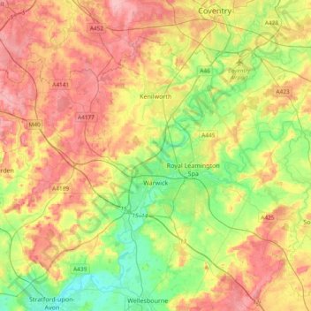
Nome: Mappa topografica Warwick, altitudine, rilievo.
Luogo: Warwick, Warwickshire, England, United Kingdom (52.21370 -1.78018 52.38928 -1.40608)
Altitudine media: 87 m
Altitudine minima: 36 m
Altitudine massima: 145 m
Fai una donazione
Preparati per la tua prossima avventura:
In qualità di associato Amazon, questo sito riceve una commissione sugli acquisti idonei senza alcun costo aggiuntivo per te.
Altre mappe topografiche
Clicca su una mappa per visualizzarne la topografia, l'altitudine e il rilievo.
Holbech's Wood
United Kingdom > England > Warwickshire > North Warwickshire > Fillongley CP
Altitudine media: 140 m
Fai una donazione
Preparati per la tua prossima avventura:
In qualità di associato Amazon, questo sito riceve una commissione sugli acquisti idonei senza alcun costo aggiuntivo per te.
Hoar Park
United Kingdom > England > Warwickshire > North Warwickshire > Bentley CP
Altitudine media: 135 m
Hunts Green
United Kingdom > England > Warwickshire > North Warwickshire > Middleton CP
Altitudine media: 81 m
Fai una donazione
Preparati per la tua prossima avventura:
In qualità di associato Amazon, questo sito riceve una commissione sugli acquisti idonei senza alcun costo aggiuntivo per te.
Marlcliff
United Kingdom > England > Warwickshire > Stratford-on-Avon > Bidford on Avon CP
Altitudine media: 41 m
River Avon
United Kingdom > England > Warwickshire > Stratford-on-Avon > Stratford-upon-Avon > Clifford Chambers
Altitudine media: 43 m
Big Clowes Wood
United Kingdom > England > Warwickshire > Stratford-on-Avon > Tanworth in Arden CP
Altitudine media: 152 m
Arlescote
United Kingdom > England > Warwickshire > Stratford-on-Avon > Warmington CP
Altitudine media: 148 m
Fai una donazione
Preparati per la tua prossima avventura:
In qualità di associato Amazon, questo sito riceve una commissione sugli acquisti idonei senza alcun costo aggiuntivo per te.
Bishopton
United Kingdom > England > Warwickshire > Stratford-on-Avon > Stratford-upon-Avon
Altitudine media: 64 m
Fai una donazione
Preparati per la tua prossima avventura:
In qualità di associato Amazon, questo sito riceve una commissione sugli acquisti idonei senza alcun costo aggiuntivo per te.
Fai una donazione
Preparati per la tua prossima avventura:
In qualità di associato Amazon, questo sito riceve una commissione sugli acquisti idonei senza alcun costo aggiuntivo per te.
Brook End
United Kingdom > England > Warwickshire > North Warwickshire > Hurley
Altitudine media: 107 m
Brinklow Marina
United Kingdom > England > Warwickshire > Rugby > King's Newnham CP
Altitudine media: 95 m
Fai una donazione
Preparati per la tua prossima avventura:
In qualità di associato Amazon, questo sito riceve una commissione sugli acquisti idonei senza alcun costo aggiuntivo per te.
Walton
United Kingdom > England > Warwickshire > Stratford-on-Avon > Wellesbourne
Altitudine media: 76 m
Vale View
United Kingdom > England > Warwickshire > Nuneaton and Bedworth > Nuneaton
Altitudine media: 113 m
Fai una donazione
Preparati per la tua prossima avventura:
In qualità di associato Amazon, questo sito riceve una commissione sugli acquisti idonei senza alcun costo aggiuntivo per te.
Ascott
United Kingdom > England > Warwickshire > Stratford-on-Avon > Whichford
Altitudine media: 160 m
Fai una donazione
Preparati per la tua prossima avventura:
In qualità di associato Amazon, questo sito riceve una commissione sugli acquisti idonei senza alcun costo aggiuntivo per te.
Edstone
United Kingdom > England > Warwickshire > Stratford-on-Avon > Wootton Wawen CP
Altitudine media: 90 m
Sutton-under-Brailes
United Kingdom > England > Warwickshire > Stratford-on-Avon > Stourton
Altitudine media: 125 m
Fai una donazione
Preparati per la tua prossima avventura:
In qualità di associato Amazon, questo sito riceve una commissione sugli acquisti idonei senza alcun costo aggiuntivo per te.
Fai una donazione
Preparati per la tua prossima avventura:
In qualità di associato Amazon, questo sito riceve una commissione sugli acquisti idonei senza alcun costo aggiuntivo per te.
Fai una donazione
Preparati per la tua prossima avventura:
In qualità di associato Amazon, questo sito riceve una commissione sugli acquisti idonei senza alcun costo aggiuntivo per te.
Nuneaton Common
United Kingdom > England > Warwickshire > Nuneaton and Bedworth
Altitudine media: 127 m
Fai una donazione
Preparati per la tua prossima avventura:
In qualità di associato Amazon, questo sito riceve una commissione sugli acquisti idonei senza alcun costo aggiuntivo per te.
Fai una donazione
Preparati per la tua prossima avventura:
In qualità di associato Amazon, questo sito riceve una commissione sugli acquisti idonei senza alcun costo aggiuntivo per te.
Fai una donazione
Preparati per la tua prossima avventura:
In qualità di associato Amazon, questo sito riceve una commissione sugli acquisti idonei senza alcun costo aggiuntivo per te.
Fai una donazione
Preparati per la tua prossima avventura:
In qualità di associato Amazon, questo sito riceve una commissione sugli acquisti idonei senza alcun costo aggiuntivo per te.
Church End
United Kingdom > England > Warwickshire > North Warwickshire > Ansley CP
Altitudine media: 151 m
Burton Dassett Hills Country Park
United Kingdom > England > Warwickshire > Stratford-on-Avon > Northend > Burton Dassett CP
Altitudine media: 132 m
Fai una donazione
Preparati per la tua prossima avventura:
In qualità di associato Amazon, questo sito riceve una commissione sugli acquisti idonei senza alcun costo aggiuntivo per te.
Hartshill Hayes Country Park
United Kingdom > England > Warwickshire > North Warwickshire > Ansley Common
Altitudine media: 127 m
Cranhill
United Kingdom > England > Warwickshire > Stratford-on-Avon > Ardens Grafton
Altitudine media: 57 m
Fai una donazione
Preparati per la tua prossima avventura:
In qualità di associato Amazon, questo sito riceve una commissione sugli acquisti idonei senza alcun costo aggiuntivo per te.
Curdworth Locks
United Kingdom > England > Warwickshire > North Warwickshire > Kingsbury > Curdworth CP
Altitudine media: 80 m
Oversley Wood
United Kingdom > England > Warwickshire > Stratford-on-Avon > Alcester > Exhall
Altitudine media: 64 m
Merevale Lake
United Kingdom > England > Warwickshire > North Warwickshire > Atherstone
Altitudine media: 119 m
Fai una donazione
Preparati per la tua prossima avventura:
In qualità di associato Amazon, questo sito riceve una commissione sugli acquisti idonei senza alcun costo aggiuntivo per te.
Pillerton Hersey
United Kingdom > England > Warwickshire > Stratford-on-Avon > Pillerton Hersey
Altitudine media: 92 m
Fai una donazione
Preparati per la tua prossima avventura:
In qualità di associato Amazon, questo sito riceve una commissione sugli acquisti idonei senza alcun costo aggiuntivo per te.
Pathlow
United Kingdom > England > Warwickshire > Stratford-on-Avon > Wilmcote CP
Altitudine media: 84 m
Fai una donazione
Preparati per la tua prossima avventura:
In qualità di associato Amazon, questo sito riceve una commissione sugli acquisti idonei senza alcun costo aggiuntivo per te.
Napton on the Hill
United Kingdom > England > Warwickshire > Stratford-on-Avon
Altitudine media: 113 m
Fai una donazione
Preparati per la tua prossima avventura:
In qualità di associato Amazon, questo sito riceve una commissione sugli acquisti idonei senza alcun costo aggiuntivo per te.
Lower Binton
United Kingdom > England > Warwickshire > Stratford-on-Avon > Binton
Altitudine media: 52 m
Pooley Country Park
United Kingdom > England > Warwickshire > North Warwickshire > Polesworth
Altitudine media: 76 m
Lea Marston Purification Lakes
United Kingdom > England > Warwickshire > North Warwickshire > Marston
Altitudine media: 70 m
Fai una donazione
Preparati per la tua prossima avventura:
In qualità di associato Amazon, questo sito riceve una commissione sugli acquisti idonei senza alcun costo aggiuntivo per te.
Hampton on the Hill
United Kingdom > England > Warwickshire > Warwick > Hampton on the Hill
Altitudine media: 75 m
Fai una donazione
Preparati per la tua prossima avventura:
In qualità di associato Amazon, questo sito riceve una commissione sugli acquisti idonei senza alcun costo aggiuntivo per te.
Horeston Grange
United Kingdom > England > Warwickshire > Nuneaton and Bedworth
Altitudine media: 90 m
Fai una donazione
Preparati per la tua prossima avventura:
In qualità di associato Amazon, questo sito riceve una commissione sugli acquisti idonei senza alcun costo aggiuntivo per te.
Ladbroke (Millennium Green)
United Kingdom > England > Warwickshire > Stratford-on-Avon > Ladbroke CP
Altitudine media: 98 m
Bishop's Itchington
United Kingdom > England > Warwickshire > Stratford-on-Avon
Altitudine media: 105 m
Winderton
United Kingdom > England > Warwickshire > Stratford-on-Avon > Winderton
Altitudine media: 151 m
Upper Quinton
United Kingdom > England > Warwickshire > Stratford-on-Avon > Lower Quinton > Upper Quinton
Altitudine media: 70 m
Fai una donazione
Preparati per la tua prossima avventura:
In qualità di associato Amazon, questo sito riceve una commissione sugli acquisti idonei senza alcun costo aggiuntivo per te.