
Fai una donazione
Preparati per la tua prossima avventura:
In qualità di associato Amazon, questo sito riceve una commissione sugli acquisti idonei senza alcun costo aggiuntivo per te.
Mappa topografica Diablo Lake
Clicca sulla mappa per visualizzare l'altitudine.
Fai una donazione
Preparati per la tua prossima avventura:
In qualità di associato Amazon, questo sito riceve una commissione sugli acquisti idonei senza alcun costo aggiuntivo per te.
Diablo Lake
Diablo Lake is a reservoir in the North Cascade mountains of northern Washington state, United States. Created by Diablo Dam, the lake is located between Ross Lake and Gorge Lake on the Skagit River at an elevation of 1,201 feet (366 m) above sea level. Diablo Lake is part of the Skagit River Hydroelectric Project and managed by Seattle City Light.
Fai una donazione
Preparati per la tua prossima avventura:
In qualità di associato Amazon, questo sito riceve una commissione sugli acquisti idonei senza alcun costo aggiuntivo per te.
A proposito di questa mappa
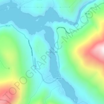
Nome: Mappa topografica Diablo Lake, altitudine, rilievo.
Luogo: Diablo Lake, Whatcom County, Washington, United States (48.68160 -121.13257 48.72013 -121.08459)
Altitudine media: 643 m
Altitudine minima: 362 m
Altitudine massima: 1.538 m
Fai una donazione
Preparati per la tua prossima avventura:
In qualità di associato Amazon, questo sito riceve una commissione sugli acquisti idonei senza alcun costo aggiuntivo per te.
Altre mappe topografiche
Clicca su una mappa per visualizzarne la topografia, l'altitudine e il rilievo.
Fai una donazione
Preparati per la tua prossima avventura:
In qualità di associato Amazon, questo sito riceve una commissione sugli acquisti idonei senza alcun costo aggiuntivo per te.
Fai una donazione
Preparati per la tua prossima avventura:
In qualità di associato Amazon, questo sito riceve una commissione sugli acquisti idonei senza alcun costo aggiuntivo per te.
Mount Redoubt
United States > Washington > Whatcom County
The North Cascades features some of the most rugged topography in the Cascade Range with craggy peaks, spires, ridges, and deep glacial valleys. Geological events occurring many years ago created the diverse topography and drastic elevation changes over the Cascade Range leading to the various climate…
Altitudine media: 2.070 m
Ruby Mountain
United States > Washington > Whatcom County
Ruby Mountain is a prominent 7,412-foot (2,259-metre) mountain summit located in the North Cascades Range of Washington state. It is situated in Ross Lake National Recreation Area which is part of the North Cascades National Park Complex. The Diablo Lake Overlook along the North Cascades Highway is at the foot…
Altitudine media: 1.731 m
Fai una donazione
Preparati per la tua prossima avventura:
In qualità di associato Amazon, questo sito riceve una commissione sugli acquisti idonei senza alcun costo aggiuntivo per te.
Fai una donazione
Preparati per la tua prossima avventura:
In qualità di associato Amazon, questo sito riceve una commissione sugli acquisti idonei senza alcun costo aggiuntivo per te.
Fai una donazione
Preparati per la tua prossima avventura:
In qualità di associato Amazon, questo sito riceve una commissione sugli acquisti idonei senza alcun costo aggiuntivo per te.
Bellingham
United States > Washington > Whatcom County > Bellingham
According to the United States Census Bureau, the city has a total area of 28.90 square miles (74.85 km2), of which, 27.08 square miles (70.14 km2) is land and 1.82 square miles (4.71 km2) is water. The lowest elevations are at sea level along the waterfront. Alabama Hill is one of the higher points in the…
Altitudine media: 129 m