
Mappa topografica New Town
Clicca sulla mappa per visualizzare l'altitudine.
A proposito di questa mappa
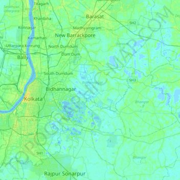
Nome: Mappa topografica New Town, altitudine, rilievo.
Altitudine media: 5 m
Altitudine minima: -3 m
Altitudine massima: 22 m
Altre mappe topografiche
Clicca su una mappa per visualizzarne la topografia, l'altitudine e il rilievo.
Bidhannagar
India > West Bengal > Bidhannagar
According to the Bidhannagar Municipal Corporation, the city area has a total area of 55.51 square kilometres (21.43 sq mi), with approx 30.51 square kilometres (11.78 sq mi) of it being land, and approx 25 square kilometres (9.7 sq mi), or 45.5% of the total, being covered by water. It has an average…
Altitudine media: 5 m
Bidhannagar
India > West Bengal > Bidhannagar
Bidhannagar is located at 22°35′N 88°25′E / 22.58°N 88.42°E / 22.58; 88.42. It has an average elevation of 11 metres (49 ft).
Altitudine media: 5 m
Bidhannagar
India > West Bengal > Bidhannagar
According to the Bidhannagar Municipal Corporation, the city area has a total area of 55.51 square kilometres (21.43 sq mi), with approx 30.51 square kilometres (11.78 sq mi) of it being land, and approx 25 square kilometres (9.7 sq mi), or 45.5% of the total, being covered by water. It has an average…
Altitudine media: 5 m
Bidhannagar
India > West Bengal > Bidhannagar
Bidhannagar is located at 22°35′N 88°25′E / 22.58°N 88.42°E / 22.58; 88.42. It has an average elevation of 11 metres (49 ft).
Altitudine media: 5 m