
Mappa topografica Ravangla
Clicca sulla mappa per visualizzare l'altitudine.
Ravangla
Rabong or Ravangla is a small town with an elevation of 8000 feet located, near Namchi City in the Namchi district of the Indian state of Sikkim. It is connected by state highway to other major towns in the state and lies between Namchi, Pelling and Gangtok. It is the starting point for the trek to Maenam Wildlife Sanctuary. It is approximately 65 km from the state capital, Gangtok, and 120 km from Siliguri, West Bengal. The name is derived from the Sikkimese language. ‘Ra’ means wild sheep, 'vong' translates to a rearing place, and ‘la’ means a pass.
A proposito di questa mappa
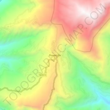
Nome: Mappa topografica Ravangla, altitudine, rilievo.
Luogo: Ravangla, Ravong, Namchi, Sikkim, 737139, India (27.26513 88.32447 27.34513 88.40447)
Altitudine media: 1.870 m
Altitudine minima: 682 m
Altitudine massima: 3.229 m
Altre mappe topografiche
Clicca su una mappa per visualizzarne la topografia, l'altitudine e il rilievo.