
Fai una donazione
Preparati per la tua prossima avventura:
In qualità di associato Amazon, questo sito riceve una commissione sugli acquisti idonei senza alcun costo aggiuntivo per te.
Mappa topografica Sylt
Clicca sulla mappa per visualizzare l'altitudine.
Fai una donazione
Preparati per la tua prossima avventura:
In qualità di associato Amazon, questo sito riceve una commissione sugli acquisti idonei senza alcun costo aggiuntivo per te.
Sylt
The island's shape has constantly shifted over time, a process which is still ongoing today. The northern and southern spits of Sylt are exclusively made up of infertile sand deposits, while the central part with the municipalities of Westerland, Wenningstedt-Braderup and Sylt-Ost consists of a geestland core, which becomes apparent in the form of the Red Cliff of Wenningstedt. The geestland facing the Wadden Sea gradually turns into fertile marshland around Sylt-Ost. Sylt has only been an island since the Grote Mandrenke flood of 1362. The so-called Uwe-Düne (Uwe Dune) is the island's highest elevation with 52.5 metres (172.2 feet) above sea level.
Fai una donazione
Preparati per la tua prossima avventura:
In qualità di associato Amazon, questo sito riceve una commissione sugli acquisti idonei senza alcun costo aggiuntivo per te.
A proposito di questa mappa
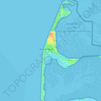
Nome: Mappa topografica Sylt, altitudine, rilievo.
Luogo: Sylt, Northern Friesland, Schleswig-Holstein, Germany (54.74589 8.27846 55.05866 8.48996)
Altitudine media: 0 m
Altitudine minima: -3 m
Altitudine massima: 35 m
Fai una donazione
Preparati per la tua prossima avventura:
In qualità di associato Amazon, questo sito riceve una commissione sugli acquisti idonei senza alcun costo aggiuntivo per te.
Altre mappe topografiche
Clicca su una mappa per visualizzarne la topografia, l'altitudine e il rilievo.