
Fai una donazione
Preparati per la tua prossima avventura:
In qualità di associato Amazon, questo sito riceve una commissione sugli acquisti idonei senza alcun costo aggiuntivo per te.
Mappa topografica Mill Creek Point
Clicca sulla mappa per visualizzare l'altitudine.
Fai una donazione
Preparati per la tua prossima avventura:
In qualità di associato Amazon, questo sito riceve una commissione sugli acquisti idonei senza alcun costo aggiuntivo per te.
A proposito di questa mappa
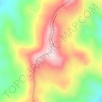
Nome: Mappa topografica Mill Creek Point, altitudine, rilievo.
Altitudine media: 1.275 m
Altitudine minima: 1.038 m
Altitudine massima: 1.498 m
Fai una donazione
Preparati per la tua prossima avventura:
In qualità di associato Amazon, questo sito riceve una commissione sugli acquisti idonei senza alcun costo aggiuntivo per te.
Altre mappe topografiche
Clicca su una mappa per visualizzarne la topografia, l'altitudine e il rilievo.
Newport
United States > Washington > Pend Oreille County
Newport is located at an elevation of 2,160 feet (658.5 m) and according to the United States Census Bureau, the city has a total area of 1.07 square miles (2.77 km2), all of it land.
Altitudine media: 662 m
Ione
United States > Washington > Pend Oreille County
Ione is situated on the west bank of the Pend Oreille River as it flows north towards Canada. Big Muddy Creek, Little Muddy Creek and Cedar Creek, from south to north, join the river in Ione. State Route 31 passes through town. Ione Bridge, on the southern edge of town, is the only road crossing of the Pend…
Altitudine media: 670 m
Kalispel Reservation
United States > Washington > Pend Oreille County > Airway Heights
Altitudine media: 801 m
Fai una donazione
Preparati per la tua prossima avventura:
In qualità di associato Amazon, questo sito riceve una commissione sugli acquisti idonei senza alcun costo aggiuntivo per te.
Newport
United States > Washington > Pend Oreille County
Newport is located at an elevation of 2,160 feet (658.5 m) and according to the United States Census Bureau, the city has a total area of 1.07 square miles (2.77 km2), all of it land.
Altitudine media: 662 m
Fai una donazione
Preparati per la tua prossima avventura:
In qualità di associato Amazon, questo sito riceve una commissione sugli acquisti idonei senza alcun costo aggiuntivo per te.