
Mappa topografica Oxford
Mappa interattiva
Clicca sulla mappa per visualizzare l'altitudine.
A proposito di questa mappa
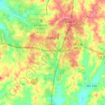
Nome: Mappa topografica Oxford, altitudine, rilievo.
Luogo: Oxford, Lafayette County, Mississippi, United States (34.31046 -89.59668 34.39417 -89.47522)
Altitudine media: 132 m
Altitudine minima: 92 m
Altitudine massima: 178 m
The city is located in the North Central Hills region of Mississippi. The region is known for its heavily forested hills made up of red clay. The area is higher and greater in relief than areas to the west (such as the Mississippi Delta or loess bluffs along the Delta), but lower in elevation than areas in northeast Mississippi. The changes in elevation can be noticed when traveling on the Highway 6 bypass, since the east-west highway tends to transect many of the north-south ridges. Downtown Oxford sits on one of these ridges and the University of Mississippi sits on another one, while the main commercial corridors on either side of the city sit in valleys.
Altre mappe topografiche
Clicca su una mappa per visualizzarne la topografia, l'altitudine e il rilievo.
Sardis Lake
United States > Mississippi > Lafayette County
Sardis Lake, Lafayette County, Mississippi, United States
Altitudine media: 104 m
Oxford
United States > Mississippi > Lafayette County > Oxford > Oxford
Oxford, Lafayette County, Mississippi, 38655-3806, United States
Altitudine media: 137 m
University
United States > Mississippi > Lafayette County > University
University, Lafayette County, Mississippi, 38677, United States
Altitudine media: 137 m