
Mappa topografica Village of Tannersville
Mappa interattiva
Clicca sulla mappa per visualizzare l'altitudine.
A proposito di questa mappa
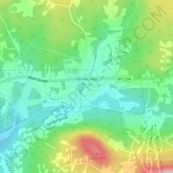
Nome: Mappa topografica Village of Tannersville, altitudine, rilievo.
Altitudine media: 613 m
Altitudine minima: 547 m
Altitudine massima: 742 m
Tannersville is located in southern Greene County at 42°11′37″N 74°8′20″W / 42.19361°N 74.13889°W / 42.19361; -74.13889 (42.193619, -74.139011), in the northern part of the town of Hunter. It is situated at an elevation of 1,900 feet (580 m) in the Catskill Mountains just west of the height of land on New York State Route 23A: Sawmill Creek flows southwest through the center of the village into Gooseberry Creek and thence into Schoharie Creek, a north-flowing tributary of the Mohawk River, while just 2 miles (3 km) to the east, at Haines Falls, Kaaterskill Creek drops east into Kaaterskill Clove and thence into the Hudson River valley.
Altre mappe topografiche
Clicca su una mappa per visualizzarne la topografia, l'altitudine e il rilievo.
Sugarloaf Mountain
United States > New York > Greene County > Town of Hunter
Sugarloaf Mountain, Town of Hunter, Greene County, New York, United States
Altitudine media: 846 m