
Fai una donazione
Preparati per la tua prossima avventura:
In qualità di associato Amazon, questo sito riceve una commissione sugli acquisti idonei senza alcun costo aggiuntivo per te.
Mappa topografica Hazleton
Clicca sulla mappa per visualizzare l'altitudine.
Fai una donazione
Preparati per la tua prossima avventura:
In qualità di associato Amazon, questo sito riceve una commissione sugli acquisti idonei senza alcun costo aggiuntivo per te.
Hazleton
In 1818, anthracite coal deposits were discovered in nearby Beaver Meadows by prospectors Nathaniel Beach and Tench Coxe. This caught the attention of railroad developers in Philadelphia. A young engineer from New York named Ariovistus "Ario" Pardee was hired to survey the topography of Beaver Meadows and report the practicality of extending a railroad from the Lehigh Canal in Jim Thorpe to Beaver Meadows. Knowing that the area of Beaver Meadows was already controlled by Coxe and Beach, Pardee bought many acres of the land in present-day Hazleton. The investment proved to be lucrative. The land contained part of a massive anthracite coal field. Pardee is known as the founding father of Hazleton because of these contributions and initially laying out the patch town that eventually became Hazleton.
Fai una donazione
Preparati per la tua prossima avventura:
In qualità di associato Amazon, questo sito riceve una commissione sugli acquisti idonei senza alcun costo aggiuntivo per te.
A proposito di questa mappa
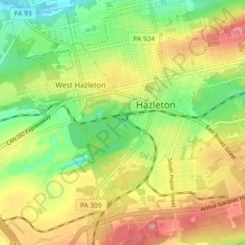
Nome: Mappa topografica Hazleton, altitudine, rilievo.
Luogo: Hazleton, Luzerne County, Pennsylvania, 18201, United States (40.92801 -75.99645 40.97487 -75.94580)
Altitudine media: 514 m
Altitudine minima: 442 m
Altitudine massima: 591 m
Fai una donazione
Preparati per la tua prossima avventura:
In qualità di associato Amazon, questo sito riceve una commissione sugli acquisti idonei senza alcun costo aggiuntivo per te.
Altre mappe topografiche
Clicca su una mappa per visualizzarne la topografia, l'altitudine e il rilievo.
Fern Glen
United States > Pennsylvania > Luzerne County > Black Creek Township
Altitudine media: 391 m
Ricketts Glen State Park
United States > Pennsylvania > Luzerne County > Fairmount Township
The state's original plans for the new park included building an inn, an 18-hole golf course and country club, and a winter sports complex for skiing, ice boating, and tobogganing, as well as a beach with bathing facilities, cabins, and a tent camping area. Only the last three were actually built, all south of…
Altitudine media: 588 m
Fai una donazione
Preparati per la tua prossima avventura:
In qualità di associato Amazon, questo sito riceve una commissione sugli acquisti idonei senza alcun costo aggiuntivo per te.
Fai una donazione
Preparati per la tua prossima avventura:
In qualità di associato Amazon, questo sito riceve una commissione sugli acquisti idonei senza alcun costo aggiuntivo per te.
Wapwallopen
United States > Pennsylvania > Luzerne County > Conyngham Township
Altitudine media: 223 m
Roaring Brook
United States > Pennsylvania > Luzerne County > Hunlock Township
Altitudine media: 337 m
Fai una donazione
Preparati per la tua prossima avventura:
In qualità di associato Amazon, questo sito riceve una commissione sugli acquisti idonei senza alcun costo aggiuntivo per te.
Fai una donazione
Preparati per la tua prossima avventura:
In qualità di associato Amazon, questo sito riceve una commissione sugli acquisti idonei senza alcun costo aggiuntivo per te.
Roaring Brook
United States > Pennsylvania > Luzerne County > Hunlock Township
Altitudine media: 337 m
Fai una donazione
Preparati per la tua prossima avventura:
In qualità di associato Amazon, questo sito riceve una commissione sugli acquisti idonei senza alcun costo aggiuntivo per te.
Liewellyn Corners
United States > Pennsylvania > Luzerne County > Bear Creek Township
Altitudine media: 449 m
South Pond Dam
United States > Pennsylvania > Luzerne County > Hanover Township
Altitudine media: 204 m
Fai una donazione
Preparati per la tua prossima avventura:
In qualità di associato Amazon, questo sito riceve una commissione sugli acquisti idonei senza alcun costo aggiuntivo per te.
Wapwallopen
United States > Pennsylvania > Luzerne County > Conyngham Township
Altitudine media: 223 m
Fai una donazione
Preparati per la tua prossima avventura:
In qualità di associato Amazon, questo sito riceve una commissione sugli acquisti idonei senza alcun costo aggiuntivo per te.
Hunlock Creek
United States > Pennsylvania > Luzerne County > Hunlock Township > Hunlock
Altitudine media: 276 m
Fai una donazione
Preparati per la tua prossima avventura:
In qualità di associato Amazon, questo sito riceve una commissione sugli acquisti idonei senza alcun costo aggiuntivo per te.
Fai una donazione
Preparati per la tua prossima avventura:
In qualità di associato Amazon, questo sito riceve una commissione sugli acquisti idonei senza alcun costo aggiuntivo per te.
Huntington Mills
United States > Pennsylvania > Luzerne County > Huntington Township
Altitudine media: 289 m
Fern Glen
United States > Pennsylvania > Luzerne County > Black Creek Township
Altitudine media: 391 m
Fai una donazione
Preparati per la tua prossima avventura:
In qualità di associato Amazon, questo sito riceve una commissione sugli acquisti idonei senza alcun costo aggiuntivo per te.