
Fai una donazione
Preparati per la tua prossima avventura:
In qualità di associato Amazon, questo sito riceve una commissione sugli acquisti idonei senza alcun costo aggiuntivo per te.
Mappa topografica Caleta Honoratos
Clicca sulla mappa per visualizzare l'altitudine.
Fai una donazione
Preparati per la tua prossima avventura:
In qualità di associato Amazon, questo sito riceve una commissione sugli acquisti idonei senza alcun costo aggiuntivo per te.
A proposito di questa mappa
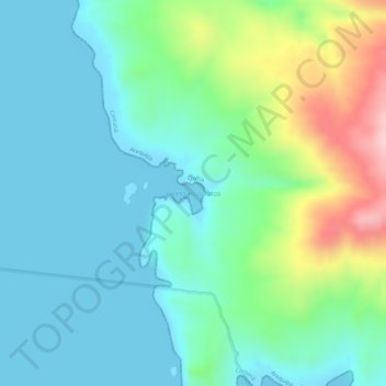
Nome: Mappa topografica Caleta Honoratos, altitudine, rilievo.
Luogo: Caleta Honoratos, Peru (-16.86073 -72.28798 -16.86063 -72.28788)
Altitudine media: 60 m
Altitudine minima: 0 m
Altitudine massima: 223 m
Fai una donazione
Preparati per la tua prossima avventura:
In qualità di associato Amazon, questo sito riceve una commissione sugli acquisti idonei senza alcun costo aggiuntivo per te.
Altre mappe topografiche
Clicca su una mappa per visualizzarne la topografia, l'altitudine e il rilievo.
Sacred Valley of the Incas
The valley, running generally west to east, is understood to include everything along the Urubamba River between the town and Inca ruins at Písac and Machu Picchu, 100 kilometres (62 mi) distant. The Sacred Valley has elevations above sea level along the river ranging from 3,000 metres (9,800 ft) at Pisac to…
Altitudine media: 3.808 m
Machu Picchu
Peru > Cusco > Machupicchu > San Miguel
Animals are also suspected to have immigrated to Machu Picchu as there were several bones found that were not native to the area. Most animal bones found were from llamas and alpacas. These animals naturally live at altitudes of 4,000 metres (13,000 ft) rather than the 2,400 metres (7,900 ft) elevation of…
Altitudine media: 2.227 m
Fai una donazione
Preparati per la tua prossima avventura:
In qualità di associato Amazon, questo sito riceve una commissione sugli acquisti idonei senza alcun costo aggiuntivo per te.
Fai una donazione
Preparati per la tua prossima avventura:
In qualità di associato Amazon, questo sito riceve una commissione sugli acquisti idonei senza alcun costo aggiuntivo per te.
Manu National Park
Manu National Park covers an area of 1,716,295.22 hectares (17,162.95 km2) which comprises mountainous areas (traversed by creeks and valleys) with elevations close to 4000 m above sea level and a portion of the Amazon Basin plains.
Altitudine media: 1.010 m
Fai una donazione
Preparati per la tua prossima avventura:
In qualità di associato Amazon, questo sito riceve una commissione sugli acquisti idonei senza alcun costo aggiuntivo per te.
Fai una donazione
Preparati per la tua prossima avventura:
In qualità di associato Amazon, questo sito riceve una commissione sugli acquisti idonei senza alcun costo aggiuntivo per te.
Villa Rica
The District of Villa Rica is on the eastern slopes of the Andes mountains in an area of abundant rainfall and mild temperatures. It is located in the ecological zone of the Peruvian Yungas, or Ceja de Selva ("eyebrow of the jungle"), the transition zone between the low jungles of the Amazon Basin and the…
Altitudine media: 1.708 m
Fai una donazione
Preparati per la tua prossima avventura:
In qualità di associato Amazon, questo sito riceve una commissione sugli acquisti idonei senza alcun costo aggiuntivo per te.
Cordillera Huayhuash
The area preserves high elevation Andean grasslands and patches of forest. Some of the native tree species present in the area are the Andean alder and trees of the genus Polylepis.
Altitudine media: 4.826 m
Fai una donazione
Preparati per la tua prossima avventura:
In qualità di associato Amazon, questo sito riceve una commissione sugli acquisti idonei senza alcun costo aggiuntivo per te.
Amazonas
The Amazonian Andes are constituted by the oriental flank of the Andes, covered originally by a dense Amazon vegetation. It spread from the cordillera spurs until reaching surprising altitudes where the forests have not been felled, in certain cases exceeding the 3 500 m.
Altitudine media: 1.119 m
Huánuco
Huánuco has a rugged topography, comprising parts of the Sierra and the High Jungle (mountain rim) regions. Being equidistant from the north and the south of the country, it has the privilege of having a mild weather with an average annual temperature of 20 °C (68 °F).
Altitudine media: 1.829 m
Fai una donazione
Preparati per la tua prossima avventura:
In qualità di associato Amazon, questo sito riceve una commissione sugli acquisti idonei senza alcun costo aggiuntivo per te.
Fai una donazione
Preparati per la tua prossima avventura:
In qualità di associato Amazon, questo sito riceve una commissione sugli acquisti idonei senza alcun costo aggiuntivo per te.
Lake Titicaca
Lake Titicaca has a surface elevation of 3,812 m (12,507 ft). The "highest navigable lake" claim is generally considered to refer to commercial craft. Numerous smaller bodies of water around the world are at higher elevations. For many years, the largest vessel afloat on the lake was the 2,200-ton (2,425 U.S.…
Altitudine media: 3.870 m
Fai una donazione
Preparati per la tua prossima avventura:
In qualità di associato Amazon, questo sito riceve una commissione sugli acquisti idonei senza alcun costo aggiuntivo per te.
Fai una donazione
Preparati per la tua prossima avventura:
In qualità di associato Amazon, questo sito riceve una commissione sugli acquisti idonei senza alcun costo aggiuntivo per te.
Cusco
The plain of Anta contains some of the best communal cultivated lands of the Department of Cusco. It is located about 3,000 metres (9,800 ft) above sea level and is used to cultivate mainly high altitude crops such as potatoes, tarwi (edible lupin), barley and quinoa.
Altitudine media: 2.719 m
Sacsayhuamán
Peru > Cusco > Cuzco > Mollococha
Sacsayhuamán (/ˈsæksaɪˌwʌmən/ SACK-sy-wuh-mən; Spanish pronunciation: [saksajwaˈman]) or Saksaywaman (from Quechua Saksay waman pukara, pronounced [ˈsaksaj ˈwaman], lit. 'fortress of the royal falcon or hawk') is a citadel on the northern outskirts of the city of Cusco, Peru, the historic capital…
Altitudine media: 3.578 m
Fai una donazione
Preparati per la tua prossima avventura:
In qualità di associato Amazon, questo sito riceve una commissione sugli acquisti idonei senza alcun costo aggiuntivo per te.
Huascarán National Park
Huascarán National Park protects the Cordillera Blanca, which is the world's highest tropical mountain range. Located in the central Peruvian Andes, the park's 340,000 hectares (840,000 acres) cover an elevational range from around 2,500 meters (8,200 ft) to the several snow-capped peaks above 6,000 meters…
Altitudine media: 3.681 m
Fai una donazione
Preparati per la tua prossima avventura:
In qualità di associato Amazon, questo sito riceve una commissione sugli acquisti idonei senza alcun costo aggiuntivo per te.
Fai una donazione
Preparati per la tua prossima avventura:
In qualità di associato Amazon, questo sito riceve una commissione sugli acquisti idonei senza alcun costo aggiuntivo per te.
Fai una donazione
Preparati per la tua prossima avventura:
In qualità di associato Amazon, questo sito riceve una commissione sugli acquisti idonei senza alcun costo aggiuntivo per te.
Fai una donazione
Preparati per la tua prossima avventura:
In qualità di associato Amazon, questo sito riceve una commissione sugli acquisti idonei senza alcun costo aggiuntivo per te.
Tingo María
Tingo María was considered unreachable until 1936, when the Montaña Road reached the settlement. It was then that the state run Estacion Experimental Agricola was established due to its "comfortable" elevation (2,204 ft). In 1942, the U.S. Government began adding more funding to the station, and by 1960 over…
Altitudine media: 841 m
Fai una donazione
Preparati per la tua prossima avventura:
In qualità di associato Amazon, questo sito riceve una commissione sugli acquisti idonei senza alcun costo aggiuntivo per te.
Laguna Palcacocha
Peru > Ancash > Independencia
Palcacocha is located at 9°23′49″S 77°22′47″W / 9.39694°S 77.37972°W / -9.39694; -77.37972 in the Ancash Region in Cordillera Blanca at an elevation of 4,566 m, just below the summits of Palcaraju (6,274 m) and Pucaranra (6,156 m). The lake is one of several lakes supplying the town Huaraz…
Altitudine media: 4.857 m
Fai una donazione
Preparati per la tua prossima avventura:
In qualità di associato Amazon, questo sito riceve una commissione sugli acquisti idonei senza alcun costo aggiuntivo per te.
Los Pantanos de Villa Wildlife Refuge
Pantanos de Villa Wildlife Refuge consists of a series of brackish water lagoons and marshes. These wetlands are formed by the filtration and discharge of water from the Ate-Surco-Chorrillos irrigation canal (which branches off from the Rimac River) and other underground canals. Elevational range inside the…
Altitudine media: 11 m
Fai una donazione
Preparati per la tua prossima avventura:
In qualità di associato Amazon, questo sito riceve una commissione sugli acquisti idonei senza alcun costo aggiuntivo per te.
Lake Titicaca (Peruvian sector)
Lake Titicaca has a surface elevation of 3,812 m (12,507 ft). The "highest lake" claim is generally considered to refer to commercial craft. Numerous smaller lakes around the world are at higher elevations. For many years, the largest vessel afloat on the lake was the 2,200-ton (2,425 U.S. tons), 79 m (259 ft)…
Altitudine media: 4.012 m
Fai una donazione
Preparati per la tua prossima avventura:
In qualità di associato Amazon, questo sito riceve una commissione sugli acquisti idonei senza alcun costo aggiuntivo per te.
Province of Yungay
The Cordillera Blanca and the Cordillera Negra traverse the province. Waskaran, the highest elevation of Peru, lies on the border with the province of Carhuaz. Chakrarahu, Chopicalqui, Tullparahu and Yanarahu (Ruriqucha) belong to the highest peaks of the province. Other mountains are listed below.
Altitudine media: 3.808 m
Fai una donazione
Preparati per la tua prossima avventura:
In qualità di associato Amazon, questo sito riceve una commissione sugli acquisti idonei senza alcun costo aggiuntivo per te.
Fai una donazione
Preparati per la tua prossima avventura:
In qualità di associato Amazon, questo sito riceve una commissione sugli acquisti idonei senza alcun costo aggiuntivo per te.
Fai una donazione
Preparati per la tua prossima avventura:
In qualità di associato Amazon, questo sito riceve una commissione sugli acquisti idonei senza alcun costo aggiuntivo per te.
Junín
The region has a very heterogeneous topography. The western range located near the border with the Lima Region, has snowy and ice-covered peaks. On the east, there are high glacier valleys which end up in high plateaus (Altiplano). Among them is the Junín Plateau that is located between the cities of La Oroya…
Altitudine media: 2.657 m
Fai una donazione
Preparati per la tua prossima avventura:
In qualità di associato Amazon, questo sito riceve una commissione sugli acquisti idonei senza alcun costo aggiuntivo per te.
Fai una donazione
Preparati per la tua prossima avventura:
In qualità di associato Amazon, questo sito riceve una commissione sugli acquisti idonei senza alcun costo aggiuntivo per te.
Fai una donazione
Preparati per la tua prossima avventura:
In qualità di associato Amazon, questo sito riceve una commissione sugli acquisti idonei senza alcun costo aggiuntivo per te.