
Mappa topografica Karbi Anglong
Clicca sulla mappa per visualizzare l'altitudine.
A proposito di questa mappa
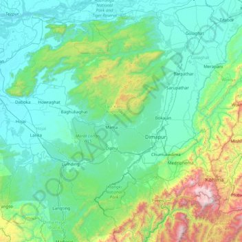
Nome: Mappa topografica Karbi Anglong, altitudine, rilievo.
Luogo: Karbi Anglong, Assam, India (25.30000 92.80000 26.70000 94.20000)
Altitudine media: 437 m
Altitudine minima: 55 m
Altitudine massima: 2.967 m
Altre mappe topografiche
Clicca su una mappa per visualizzarne la topografia, l'altitudine e il rilievo.
Karbi Anglong
Due to the variation in the topography of this hill zone, different parts of the district experiences different climates. The winter season commences from October and continues till February. During the summer season, there is a significant rise in both humidity and warmth. The temperature ranges from 6-12°…
Altitudine media: 328 m
Dhubri
Dhubri District is bounded both by interstate and international borders: West Bengal and Bangladesh in the west; Goalpara and Bogaigoan district of Assam and Garo Hills district of Meghalaya in the east; Kokrajhar district in the north; and Bangladesh and state of Meghalaya in the south. The district is…
Altitudine media: 52 m