Mappa topografica Nashville
Clicca sulla mappa per visualizzare l'altitudine.
Nashville
Nashville lies on the Cumberland River in the northwestern portion of the Nashville Basin. Nashville's elevation ranges from its lowest point, 385 feet (117 m) above sea level at the Cumberland River, to its highest point, 1,163 feet (354 m) above sea level in the Radnor Lake State Natural Area. Nashville also sits at the start of the Highland Rim, a geophysical region of very hilly land. Because of this, Nashville is very hilly. Nashville also has some stand alone hills around the city such as the hill on which the Tennessee State Capitol building sits. According to the United States Census Bureau, the city has a total area of 527.9 square miles (1,367 km2), of which 504.0 square miles (1,305 km2) of it is land and 23.9 square miles (62 km2) of it (4.53%) is water.
A proposito di questa mappa
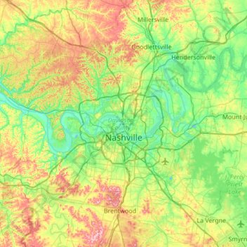
Nome: Mappa topografica Nashville, altitudine, rilievo.
Altitudine media: 184 m
Altitudine minima: 109 m
Altitudine massima: 344 m
Altre mappe topografiche
Clicca su una mappa per visualizzarne la topografia, l'altitudine e il rilievo.







Edwin Warner Park
United States > Tennessee > Davidson County > Nashville > Devonshire Manor
Altitudine media: 198 m



Huntington Ridge Estates
United States > Tennessee > Davidson County > Nashville
Altitudine media: 194 m

Harpeth River Greenway
United States > Tennessee > Davidson County > Nashville > Harpeth River Estates
Altitudine media: 182 m


Ellington Agricultural Center
United States > Tennessee > Davidson County > Nashville
Altitudine media: 178 m


Tennessee State Capitol
United States > Tennessee > Davidson County > Nashville
Altitudine media: 139 m



Northcreek Commons
United States > Tennessee > Davidson County > Goodlettsville
Altitudine media: 155 m


Hickory Valley Estates
United States > Tennessee > Davidson County > Nashville-Davidson > Hickory Valley Estates
Altitudine media: 200 m